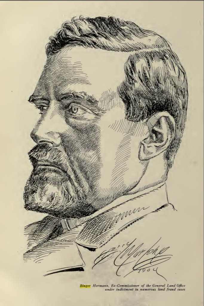
Hermann served as the Commissioner of the General Land Office for a period of about five years. His written directives known as the Binger Hermann Policy, caused mineral claimants of several lode mining claims (Ex: Lucky Strike Gold Mining Co.) to suffer from what is referred to as “cadastral mayhem” Many locators looking for a cure had to wait until August 8, 1904, when Paragraph 147 of the Mining Circular was revised under the authority of the Act of April 28, 1904.[1]
In 1904, Herman was also caught up in the Oregon land fraud scandal and brought to trial for alleged land fraud. The jury failed to agree and Hermann was never retried. Hermann was posthumously exonerated by the administration of Franklin D. Roosevelt.
The Binger Hermann Policy
The Hon. Commissioner of the General Land Office in 1899 (March 27, 1897 to January 25, 1903) was Binger Hermann. The policy did not take the form of a formal GLO circular issued by the Commissioner’s office. It was initiated by a GLO Departmental letter “N” (mineral division) regarding a survey that showed a prior official survey in a position that did not conform to its record.[9]
Mr. C.C. Goodale The U.S. Surveyor General for Colorado in his zeal to comply with the Commissioner’s “directive” created mayhem. The new policy was that a prior official survey, in conflict with the mining claim being surveyed, must be shown on the plat in its patented position rather than where the monuments on the ground marked it to be.
The policy was not well documented. A brief note on page 117 of James Underhill’s book Mineral Land Surveying, 1906:
Here it may be observed that for about five years between June 1899 and August 1904, the GLO required all claims to be figured according to their patented positions… regardless of the existence or position of the monuments on the ground. As the section ties of many claims varied from a few feet to many thousand feet from the correct distance, the official plats issued during the period mentioned above, often give a very erroneous idea of the conditions actually existing on the ground.[10]
General Land Office Departmental Letter “N” indexed 2980, dated May 20, 1899, signed by Binger Hermann, Commissioner: The surveys referred to are the Portia, Silver Pine and Edison lodes, Sur. No. 12577, approved August 13, 1898; and the Hood Lode, Sur. No. 540, original survey approved July 24, 1875, amended survey approved March 16, 1881. Note: The Departmental Letter “N” takes the Colorado Surveyor General to task that he does NOT have the authority to “amend an approved survey upon alleged errors therein, reported by another deputy surveyor…” The GLO Commissioner required a careful examination of the two surveys and report, “in full as to what would be the result of an amendment of Sur. No. 12577 so as to locate the Hood, Sur. No.540 as approved… A sketch showing the plat of Sur. No. 12577 as it now exists, and what it would be if it were made to show Sur. No. 540 as patented, would probably best illustrate the possible errors herein suggested.”
The 12577 amended Mineral survey is the first survey to suffer from the Cadastral mayhem instilled within the Binger Hermann policy, that being the sanctity of patent descriptions over original, undisturbed monuments or their perpetuations.[11]
A word of caution in using other mineral survey ties: In Colorado, and presumably in other states, there was a period where the short ties to conflicting surveys were calculated through the section corner tie. Such calculated ties should not be used. This period is not exactly known, but it ran approximately from 1898 to April 28, 1904. If a report of other surveys was contained in the field notes, the ties were not calculated.
— John V. Meldrum’s, Mineral Survey Procedures Guide(1980)[12]
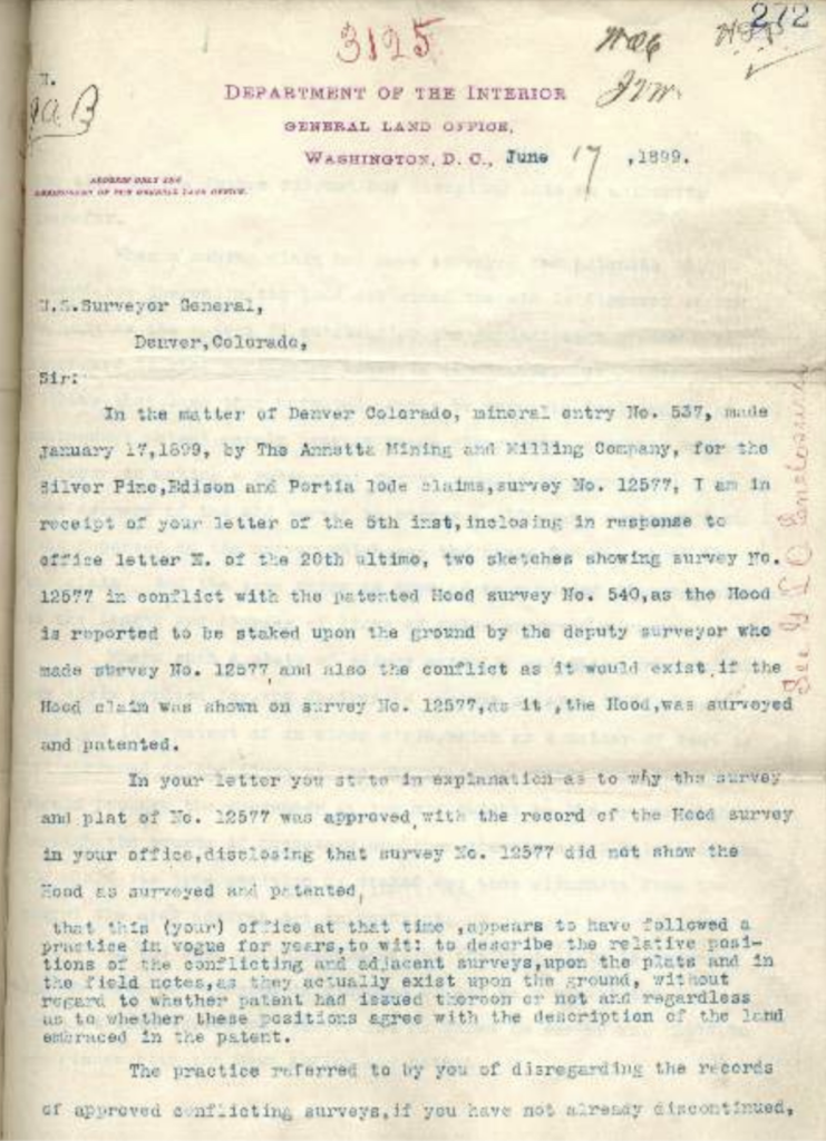
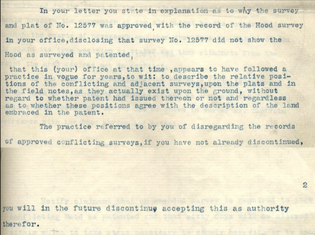
Excerpt of General Land Office Departmental Letter “N” indexed 3125, dated June 17, 1899. This letter responds to the report submitted by the Colorado Surveyor General (dated June 5, 1899) required in Departmental Letter “N” (indexed 2980). Note: This is the infamous June 17, 1899 GLO Departmental Letter “N” that is the basis of the five+ year policy referred to as the Binger Hermann policy.[11]
The Binger Hermann policy continued beyond 1904, as it is known to have reached other mining districts outside of Colorado. Records of the General Land Office containing Mineral Surveys, covering the various mineral districts of Colorado and every other mining State and Territory, showcase conditions which obtain varying degrees to land sections. As provided by the Mining Reporter on February 4, 1904, seemingly endless examples of mineral survey misconstruction already existed, compromising the public lands, patented claims. Ground which is actually unpatented and open is construed to be patented to claims which occupy entirely different tracts.[13]
Excerpt taken from the annual report prepared by Edward H. Anderson, Utah Surveyor General dated, June 30, 1901: “The Department of Interior holds that courses and distances once incorporated into a patent must be recognized in all subsequent conflicting & adjacent surveys, notwithstanding actual conditions on the ground to the contrary. This means a perpetuation of the error, if any exist, in the former patented survey, and the deputy who makes the latter survey is compelled to falsify his returns to conform to such error. The courts hold that the monuments and markings on the ground govern.” Mr. Anderson included the same paragraph in his 1902 and 1903 reports to the GLO Commissioner. Mr. Anderson’s statements are a stark reminder that the Binger Hermann policy is Cadastral vandalism of the official field notes, approved plat and patent.
Theoretical exclusions in mineral patents is only one of the two possibilities when patent description positions are held over monumented positions for prior official surveys. The other, which might be more insidious is when there is a true conflict, but the patent fails to exclude the conflict because the conflicting claims patent description position does not conflict.
— Certified Federal Surveyors Program (CFedS). Co-administered by the Department of the Interior’s Bureau of Land Management and the National Society of Professional Surveyors (NSPS)