Point of Discovery
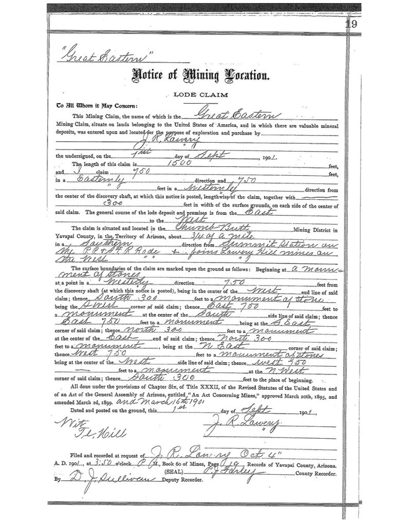
The Great Eastern lode dated September 1, 1901, is depicted on M.S. 2424 at roughly 1.08 miles southerly from the Summit Station location. The Location notice states the claim is 1500’ x 600’ and running 750 east and 750 west from the discovery shaft and situated about 3/4 mile south from the Summit Station & Joins Lowry Hill Mines on the west. We can discern that the location for the Great Eastern joined the Lowry-Hill claims the ground, simply by accepting the lode location description. The Great Eastern lode was a James Lowry mine as claimant.
The question is: What supports the depiction of the Great Eastern as presented to us in Mineral Survey 2424?
If the location notice allowed 300 ft on either side of the surface of the claim, (600’) then how can M.S. 2424 be depicting a common corner consistent with the Surenough lode, with its end line of only 550feet in length?
And why is there no indication, again, of any excluded ground on the Knocker Doom for this Great Eastern lode?
Clearly J.J. Fisher has depicted an ‘orientation‘ for the Great Eastern that overlaps the Knocker Doom lode, which was located 7 years later in 1906. This is yet another example of an exclusion that is not addressed in the field notes. By patenting the Knocker Doom lode without excluding the ground for the pre-existing 1500’x 600’ Great Eastern lode claim (remember we are assuming it is there as illustrated), a title conflict was created by the entry, survey & subsequent patent. A title conflict as to this particular aspect could be ignored, if in fact that was not actually the Great Eastern lode there, on the ground in 1907, as depicted by Fisher in M.S. 2424.
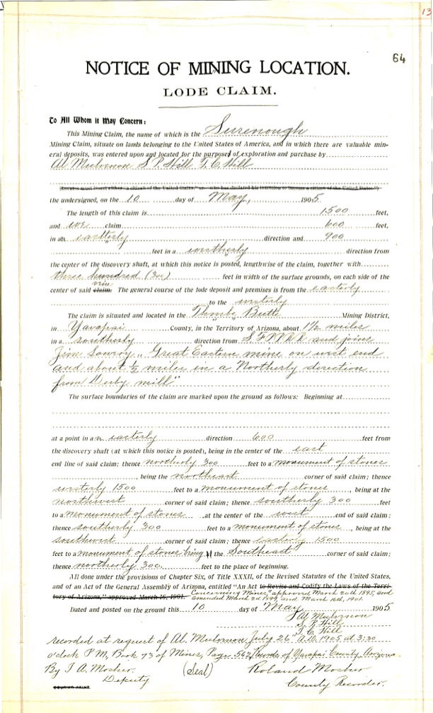
Below is a copy of the lode notice for the Surenough lode claim dated May 10, 1905. This version is apart of the GLO/BLM field notes, and is available online. The Surenough is depicted on M.S. as being contiguous with the Great Eastern lode claim.
As shown on M.S. 2424, the Surenough lode claim is 550’ x 730’. How is this possible?
The Notice of Mining Location of the Surenough, as seen below, is incorporated into the patent.
The Surenough lode is a full sized 1500’600’ claim, running 600’ east and 900’ westerly from the discovery shaft. 300 feet on either side of the claim length, not 550’.
The notice states the claim is about 1.5 miles southerly of the S.F.P.P. R.R. and joins Jim Lowry Great Eastern Mine on west end and about 1.5 miles in a northerly direction (what north) from Derby Mill (that is not the Derby, the Derby is not the Derby).
This location description although detailed, simply add much confusion as to the true ground location of the Surenough lode. As seen above, the Great Eastern was about 3/4 miles south of the fixed Summit Station. It would almost be safe to assume that the S.F.P.P. R.R. being referred to for the Surenough is also the Summit Station location. So we are an additional 3/4 mile off from the M.S. 2424 patented position, and still assuming that is the Great Eastern Location as presented by Fisher.
James R. Lowry Mining Claims
Could the claims that made up the Lowry-Hill Group of overlapped? Yes. With no official survey available for the Lowry-Hill Group, we simply do not know as to what extent, if any, or how the senior lodes were set/positioned on the ground. This is only one example of how the platting of M.S. 2424 could have been finessed by Fisher.
The second part of the ground description of the Surenough lends another unknown, as it states 1.5 miles northerly from ‘Derby Mill’. What Derby Mill in 1905 1.5 miles to the south?
Why was it considered Derby? The Derby claim couldn’t have been to the south (what south) of the Surenough 1.5 miles. Is this an arrastra site or small mill on another claim considered a Derby Mine? It is also not the Puritan Mine, which did not contain the Derby shaft, and also was not there on the ground 1.5 miles to the south of present day purported Surenough.
It is more likely that the description is claiming that the Derby Mine is the theoretical position of the Puritan Lode as M.S. platted, and the ‘mill’ that ended up being depicted on M.S. 2424 on or about the the area of the theoretical Puritan lode in the 1907 Plat by Fisher was a future intention for the plan of claim. A solid work of fiction to be considered in advance by SP Hill, TC Hill and Al Mulvernon. Samuel ‘SP’ Hill is one of the the Lowry-Hill claimants and of several claims for himself and the Ideal Mining Co., allegedly existing at the same locus.
If the claimants of the Surenough Lode are supposed to be referring to the Mill location as presented by the 1907 M.S. 2424 field notes, its location is shown on the plat. But the notice of mining location is dated 1905. This location is in a different location than the drawn plat’s depiction as referenced to a Mill location on the theoretical Puritan, and again, neither are the Derby Mill. There is no Mill on the Derby lode either, there wasn’t, nor would there be.
Back to the Surenough Lode depiction of ‘discovery’ on M.S. 2424. The claim runs 600’ to the east of this point. M.S. 2424 is depicting a discovery at almost the east end line of the Surenough, which would be leaving out nearly 600’ feet of claim to the east.
The total length platted by Fisher is only 730 feet, but Fisher is depicting that he is acknowledging the full size of the Surenough, but running it further in the wrong direction westerly to the tune of an additional 770’! There is no indication of any other shaft or discovery point for the Surenough. If this is in fact the discovery shaft as located a mere two years prior in 1905, we would have a near 600’ foot overlap over the Great Eastern Lode, which is really not an overlap since the G.E. has senior rights. This in and of itself could void the Surenough Notice of mining location. How would anyone explain the 770’ running westerly from the M.S. 2424 sideline? If any of this was to be trusted, that would be creating and additional near 600’ westerly on the plat, that never existed, nor was ever being claimed for the Surenough, according to the record.
Fisher did not survey this, someone, maybe Fisher, created it. There is no indication that he ever walked any of the lines, let alone the Surenough claim. The stretched Lode Corners drawn at S. 85deg W. are simply not mentioned in the field notes. They are fictitious projections. The end lines are also fictitious.