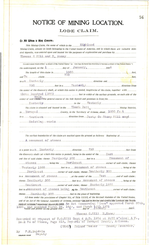
Highland Lode:
The location notice of mining location for the Highland lode claim shows it was located by TC Hill & E. Haney Jan 1 1906 and recorded on Sept 4 1906. The claim is full sized lode running east & west 750’ from the discovery shaft and 300’ on either side of the centerline.
Highland lode claim, per M.S 2424 above, shows a lode claim with a discovery shaft. The claim runs over at 769’ easterly from the discovery, and only 239’ westerly to the patented truncated end line, however Fisher depicts a total distance of still only 731’ to the west corners.
Like the Surenough claim, the Highland centerline is also not centered in relation to the sidelines, on the MS2424 depiction.
Since both the Highland and Penos Alto No. 1 were recorded at the exact same time, it is unclear where the surface rights would exist to either. There is a clear conflict of the Peno Alto No. 1 over the lode of the Highland, etc..
The total width of the Highland per Fisher comes out to only 440’, not 600’.
The end lines of the Penos Alto No. 1 are not consistent with the mining law. They are not parallel with each other, one side is 600’ and the east end line is only 400’.
The Highland claim was ‘discovered‘ January 1906, but recorded September 4 1906. The lode is supposed to exist 1800 feet south from Derby Co. Stamp Mill & Hoisting Works. The lode per mineral survey 2424 is only 1060 ‘ southerly, and a max of 1360 to the centerline of the lode, as depicted, if considering this is Puritan fictional works the locator is referring to.…
The Peno Alto No. 2 lode was discovered in 1905 and recorded in January 1906.
Field notes for M.S. 2424 show no conflict with the Highland Lode. They do however show a conflict with the mineral survey 2424 depicted Highland Lode, as far as the Peno Alto No. 2 goes…The Peno Alto No. 2 lode existed before the Highland lode, and was recorded prior to the Highland.
The Peno Alto No. 1, according to it’s 2424 depiction, in relation to the Highland lode, is being reduced in surface or ground area, providing for the junior rights of the Highland. This is backwards.
The Peno Alto No. 1 would be the dominant senior claim. As depicted, the Highland east center end and lode would be lying within the Peno Alto No. 1 claim, the same issue exists as depicted with the ‘Happy Strike’ lode claim.
If one were to locate on the ground any of the above 1500’ x 600’ claims as recorded, they would end up with a stark contrast to the M.S. 2424 cartoon. There would be the senior claim(s) and not much else outside as far as patenting the spaces of the rest of the ground goes. The PLAT is inside out at best, and nonexistent at worst.
*The ‘Italian’ lode is appearing to refer back to the original 1901 Italian ground in Notice description. If even the original Italian location notice, was the ground being referred to in later notices (it appears this is so), credit to the original Puritan lode as referenced in 2424, which is early 1902, which predates the 1901 Italian by Lowry. So the Italian is also being reduced by conflict in error. The field notes are again, silent as to any conflict of the depicted Puritan ground against the Italian.
The scenario is reversed between junior/senior claims and purported surface rights.
The conflicts are theoretical, because the claims, especially as depicted by Fisher, are theoretical to begin with.