
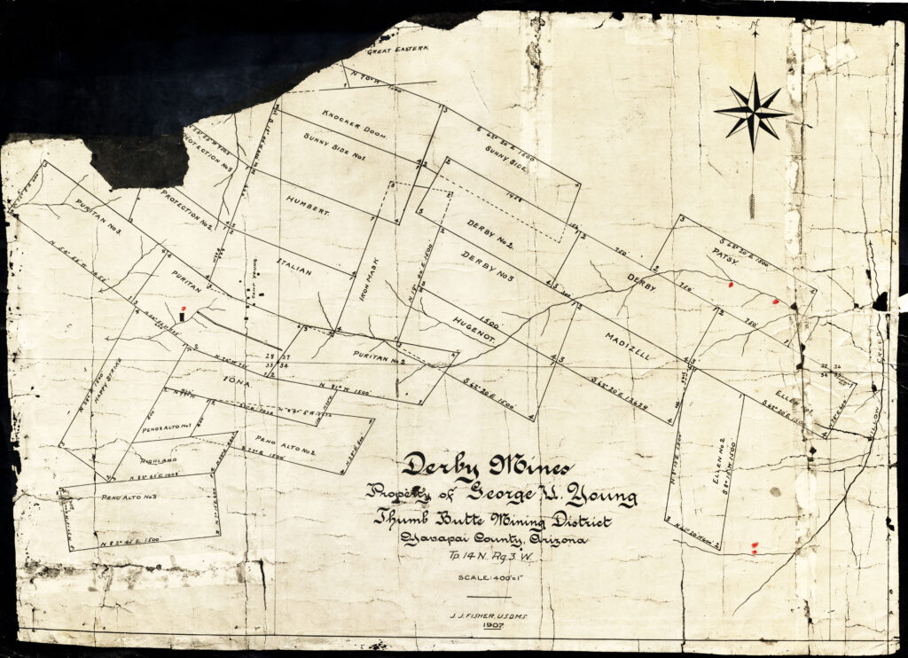
Derby Mines?
So this is not a survey, but just a drawing of an idea for the future Mineral Survey, which is also supposed to be a survey, but in actuality is not either because it is also just another drawing that looks identical to this one. The above image contains the name of J.J. Fisher, a United States Deputy Mineral Surveyor at the time in 1907. This is a prime example of a 419.692 acre ‘Bingered’ (Binger Hermann) survey variation in a ‘Bensonized’ (Foreman) township. A blunder of epic proportions in it’s entirety.
Although an exact date is not provided, the year 1907 is drawn below Fisher’s name. J.J. Fisher was also a surveyor for Yavapai County and the town of Prescott. The Mineral Survey 2424 of record, effectively mirrors this drawing. The above drawing indicates certain lode claims are in relation to ‘Willow Creek’ in their exact positions, as well as in relation to sections 28, 27, 33 and 34 in Township 14 north, and range 3 west, GSRBM. These relations are reflective of the present day location on the surface of the earth, for what is being offered as a representation of patented property, relating to this very drawing, identified as MS2424, incorporated into a serial patent deed form the U.S. in 1921.
The records of the general land office and the county of Yavapai reflect an entirely different perspective as to these lode claims by name, their ground locations as identified under the law(s), rendering this configuration entirely conjectural in nature. Even if the lode claims were valid and accepted and in this setup as drawn, and incorporated into a valid mineral patent deed from the U.S., passing a surface estate to Madizelle Mining Company (see Madizelle Mining Co.) their location would not be consistent with the present display, and can NOT ignore the senior rights as to any pre-existing mineral estate(s).
Even in a perfect world, supposing a junior/senior right was not at issue, the location notices of the various lode claims, even if aligning with the above drawing would ALSO reflect an entirely alternate reality to the above, and MS2424 respectively. It is merely impossible to ignore the very purported basis of this ‘plat’ without questioning this configuration as a whole.
The LODE Claims
The Notices of mining Claim Locations for the 25 Lode Claims in Mineral Survey 2424 are effectively all defective. Not a single one of the notices is lacking in ‘issue(s)’ especially when considering the big picture, at the time of filing, according to the laws in place at that time. Additionally, it is impossible to create the above drawing and MS2424 out of the lode claim locations as represented by the record, which is likely why the record(s) are as vague as possible. How the records scanned at that time as sufficient for notice enough to be incorporated into a patent application, and subsequently approved as being consistent with the mining laws and mineral estate requirements, is the answer to the riddle of Highland Pines.
Now back up and pretend you did not just read that last sentence….because in actuality they weren’t. You just think they were. Pay closer attention to the patent deed itself (a quit claim deed from the United States), and the language at the end regarding exclusions form conveyance, etc.. But all that will be assuming this drawing (MS2424) is legitimately reflecting actual conformity to the mineral estate and is consistent with the record of itself and the mining laws during that time. The invalid/incorrect made nothing, which was placed well….nowhere, and applying the nothing that is nowhere to the original record position in this section of the township as represented, which you have to do, and it it could only at best be one mile plus in a southerly direction, but even that is theoretical.
The record(s) have recorded something, the record(s) is a record of what it is, and not what it isn’t. Even the mineral survey 2424 depicts violations of the mining law and the requirements for discovery and filing of notices of mining claim locations on it’s face! Never mind the major issues with mineral estate at the time, which still to this day are in conflict with the present day situs (not there, wasnt there for Madizelle Mining Company, George U. Young, and likely the former promoters). Here we have a concept based on nothing, supported by nothing in or of the actual record, which was at best not in conformity to pre-patent prerequisites, or recordations, but scanned anyhow, and may have held if not positioned there of all places, absent actual fraud, which you guessed it…also exists in this instance.
If anyone actually attempted to apply the original field notes of record for this township, recreating the walk lines with the natural features of the land, they will quickly discover they are essentially on the wrong planet. It’s probable this is why a presidential proclamation forbid any settling in T14N R3W after the original ‘record’ from a known ‘Benson Syndicate’ surveyor was made ‘official’, and until resurvey was completed and filed. Mineral Survey 2424 is the basis of title to the later Highland Pines from Highland Pine Properties Inc., however MS2424 is fictional. MS 2424 is BASED ON THE ORIGINAL ‘Township survey’, not the 1931 Kinsey resurvey that took place 24 years after the fact, after the drawing above was created out of thin air. Taking into account the multiple tales of fairies, Knocker’s, mythological gold mines, the other officially ‘cancelled mineral surveys’ (see MS3884) including those of george u. young -of offical record- and well….Houston, we have a problem!
One Comment
Comments are closed.