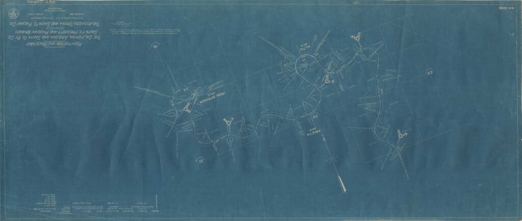
LODE-VEIN LOCATION
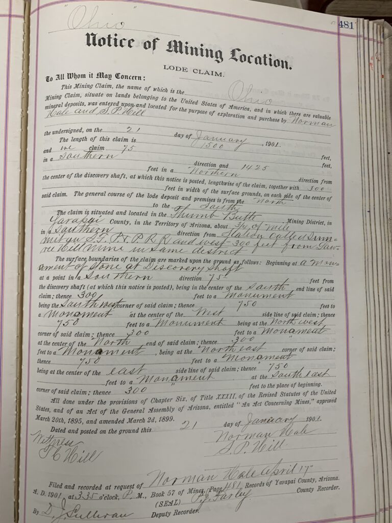
Norman Hale and ‘S.P.’ Hill Notice of Mining Location dated January 21st, 1901 for the OHIO Lode Claim in the Thumb Butte District, Prescott Yavapai County, Territory of Arizona. This a standardized 1500 x 600 foot lode claim. The claim is situated and located ‘about 3/4 mile in a Southern direction from Station called Summit on S.F.P & P. RR and west 300 feet from Lowry-Hill Mine (centerline?) in same district.‘
This notice is saying the ‘Summit’ location on the earth at that time was the first twisty area coming up Skyline Drive after you turn westerly from the original location of the ‘ALTO’ pit, the first chance to look west over the ridge heading south to Highland Pines. Would the Ohio and Lowry-Hill have been overlapping at 300 feet spanning across a 600 foot wide senior Lowry-Hill lode, vein or ledge? The ‘discovery‘ shaft is stated to be at 1425 feet northern x 75 feet southern, where the notice was posted. This notice was ‘witnessed‘ by T.C. Hill.
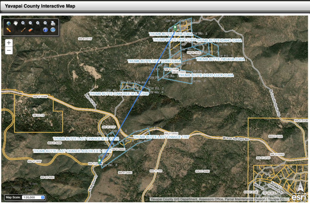
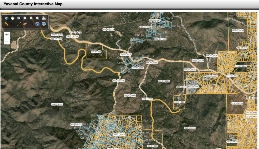
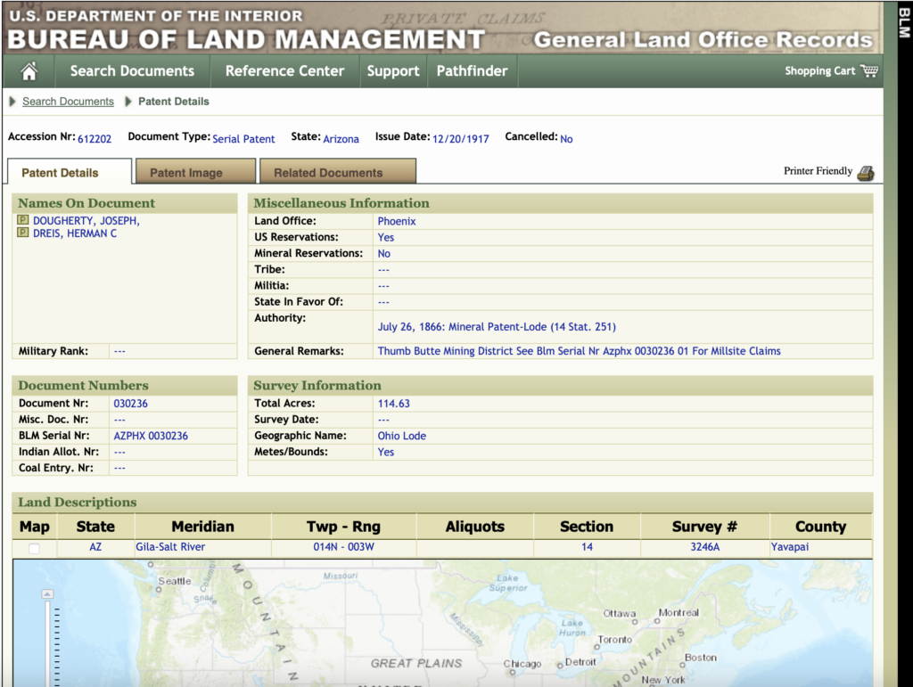
This is the same ‘OHIO’ Lode claim that is incorporated into United States Serialized Mineral Land Patent #612202 to Joseph Dougherty and Herman C. Dreis on 12/20/1917. The U.S. mineral survey that was used to patent this same OHIO lode claim, was M.S. 3246 A & B, purportedly ‘surveyed‘ February 16th, 1916, over 15 years after the notice of location was recorded in Yavapai County on April 17th, 1901, which was at the request of Mr. Norman Hale. The patent survey however, places this same lode claim in an entirely different location on the earth, notably about 3+ miles northwest of the location as shown by the notice below. The original location was in the Thumb Butte mining district, west of Prescott Arizona, South of the old Summit flag station (present day Skyline Drive).
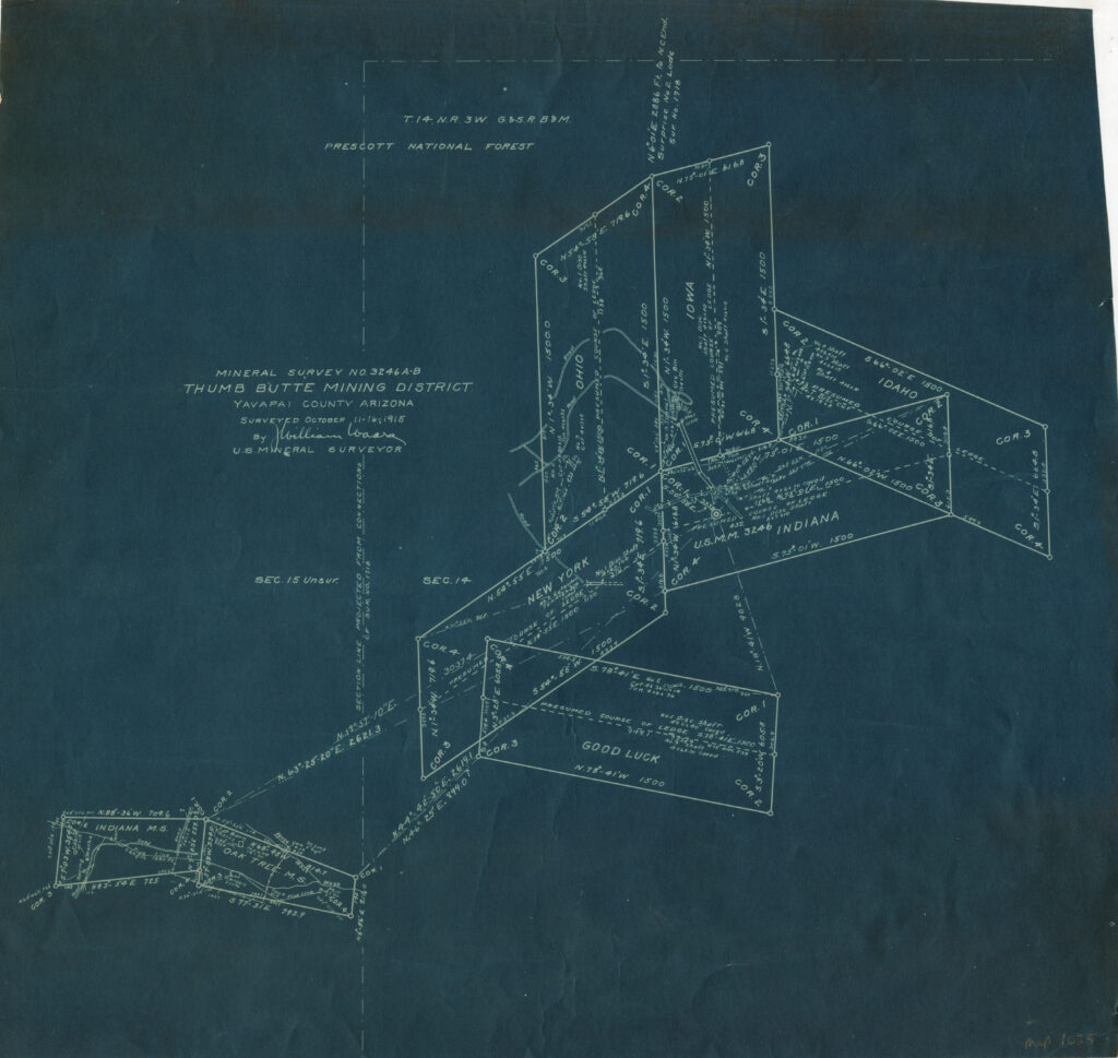
Lode Claim and Mill Site Plats
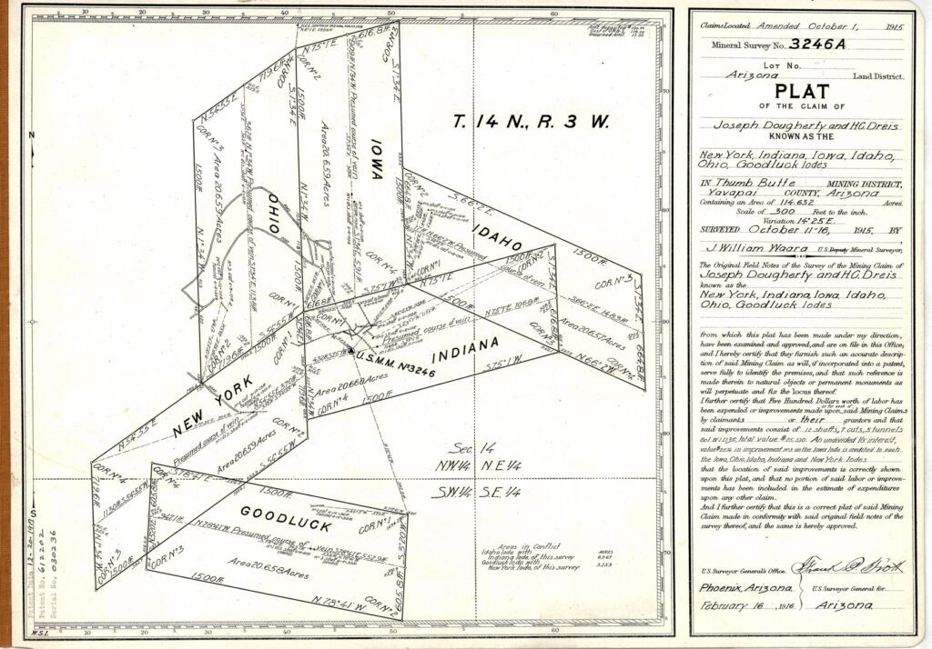
Shown above, according to the records of the Bureau of Land Management, formerly the General Land Office, is six lode mining claims, that were magically united together in an undertaking by William Waara, United States Mineral Surveyor on November 16th, 1915, about three months before the more official looking PLAT of record, the ‘patent plat’ was created to incorporate into the 1917 mineral patent.
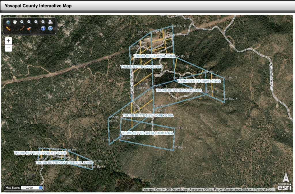
This preliminary plat shown above, is identifying the OHIO as being grouped together with the New York, Good Luck, Indiana, Iowa, and Idaho lode mining claims, all named of states in America, but still shown to be miles away from the Lowery-Hill lode claims, per the original Ohio notice of location, also above. The very interesting end lines of mill-sites 3246 B is also depicted on this preliminary plat, for the Indiana and Oak Tree Mills-Sites, which are also incorrect. All purportedly lying within sections 14 and 15 in township 14 North Range 3 west, G.S.R.M., of the Prescott National Forest.
Androit Hat Tricks
If you look closely at the centerline of each lode claim, you will see the words ‘Presumed Course of Ledge’ on each and every claim depiction. Stating the word ‘presumed’ is kind of like an artful way of clearly stating that there was never an actual ledge, vein or lode there on the ground in the first pace. It is an advance ‘copout’ for the fictitious ‘mineral survey’ that was never actually performed. It was, and still to this day is, just an area of land up in the hills outside of Prescott, in the National Forest.
Another point….even if this was a real mineral survey, to be the foundation of the patent deed, and in accordance to the mining laws etc., the present day depiction of this above things original location (we can’t really call it a mining claim because it’s not) is all bad. They are all bad. According to their own records, and mother earth, every single purportedly patented mineral lode claim in the Thumb Butte District and surrounding district’s are in essence rotten to their core.
They were never there to begin with. It is even safe to question the authenticity of the original lode claim notices, which are the same notices relating to these referenced ledges location on the surface of the earth, incorporated into subsequent land patent(s). Highland Pines is not an exception to this. Highland Pines Mineral Survey 2424, is the motherload of fictitious land surveys in the Thumb Butte mining district, or better referred to as our motherland. These are not actual mineral surveys. This is land fraud, a looting of the public domain.
Officially ‘Unofficial’
The official M.S. 3246 A PLAT finalized in February 1916, also indicates ‘presumed‘, but the word ‘Ledge’ is replaced with ‘Vein’, in contrast to the preliminary plat from November 1915. The final PLAT bears also the name of William Waara, under signature of a U.S. Surveyor General out of Phoenix. There were several out of Phoenix in this era. This PLAT was the basis for the patent deed to the surface rights, as shown by U.S. Patent No. 612202, Serial 030236, dated 12-20-1917. There is supposed to be a strict relation to the quarter section corner of section 14, according to the PLAT and corresponding ‘field notes’. Unfortunately, just like it was in the early 1900’s, if you visit any one of these purported locations today, of any of the above ‘claims’, you will not find any evidence of a ledge, a vein, or a visible lode, nor of one having ever been…there.
The conflicts are theoretical and like the other markings, simply add value to the PLAT. It should be noted that there is another section 14 & 15 relation on the preliminary PLAT, which is dated November 1915, just like the acknowledgement on the date of survey for this final PLAT of record, the patent PLAT. As shown by the preliminary PLAT signed by Waara, the section line he depicted, which should be one in the same with the final PLAT, since it is being stated they are the same ‘survey’ on the same date, written on the preliminary plat is ‘section line projected from connections of survey No. 1718. Mineral Survey 1718 is the Survey of the SURPRISE lode mining claims.
The Surprise Lode Claims and Surprise south Extension in Prescott have their own unique set of ties to section corners in the same Township 14 North Range 3 West G.S.R.M.. Waara is clearly intending on connecting his fictitious Mineral Survey 3246 A & B to the Surprise lodes location per Mineral Survey 1718. Also important to note that these are the original township section corner location, per Foreman’s 1871 Township survey. Wherever they were, which is not where they are now, if they ever existed, or could have theoretically existed, anywhere near these lodes.
Dawn’s Early Light
The location to section corners as represented on Yavapai County Mineral Survey 1718 and field notes for the Surprise Lode claims in T14N R3W, are not the same location as the claims are presented to be in accordance with their own original record, nor are they consistent with the record as presently projected by Yavapai County today. Which means even if the Arizona and Yavapai County modern projections of the original theoretical configurations were to hold, they could not simultaneously be the same lode claims and in the correct original location on the earth today, as they were shown to be, per their own respective original records.
The ridiculousness at hand, is seeing these original fictitious records still being acknowledged, against the laws that make them up in the first instance. Then the lode claims are sometimes placed somewhere in the township(s), some distances apart from other lode claims, per their secondary level of blundered record of course, all the while ignoring their other, and otherwise if valid, equal location ties that are shown on the same original document(s).
An ignorance that would change their positions in a different direction, if not ignored. Arizona and Yavapai County are presently acknowledging certain specific lands as these original blundered to be looted lands, claiming these spaces are patented private property, attempting to conform to and reflect ‘the record’. The record of their own records. The very same ‘records’ that they are simultaneously ignoring.
The relocated Lode Claim(s) like the OHIO, were not relocated to create the secondary record.
The ‘presumed’ locations of secondary ‘official‘ record, are in violation of the very mining law(s) that would have patented the new location(s), had they not been ‘secondary’, and ‘relocated’, hence the ‘presumed’. Saying something is something it is not is like having it both ways. The thing is not there.
O’er the Land of the Free and the Home of the Brave.