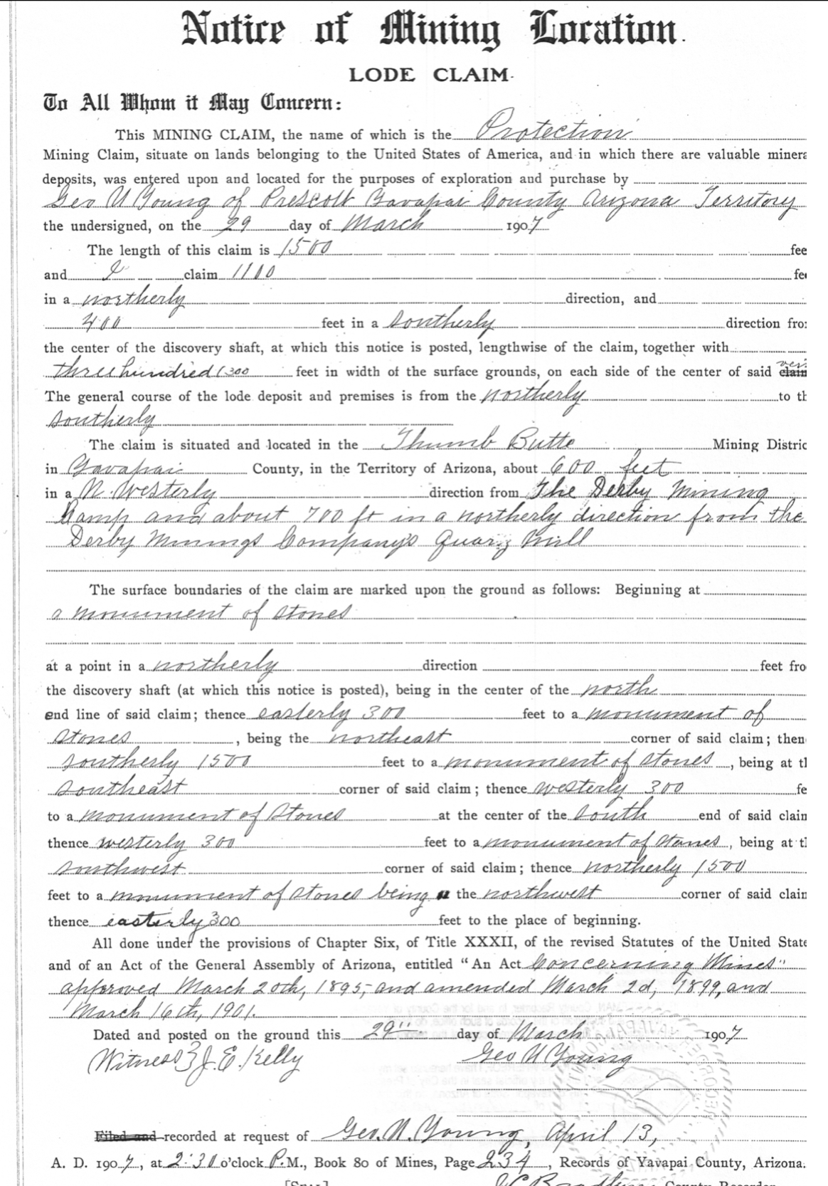
The most easterly 50’ of the depicted Protection #3 would actually be the Humbert lode, senior in right. The Protection #3 was purportedly located May 2nd 1907, recorded May 4th 1907. Again, the field notes are silent as to this conflict between the recorded location notice and the presentation on the PLAT.
The Protection #2 claim was also located the same date as the Protection #3, and recorded the same date. Both were located by Young, the Protection #3 being recorded one minute after the Protection #2.
The Protection #2 claim is depicted by Fisher at a width of only 533.5’, not 600’.
Both location notices reference a general distance from the Derby mining camp, to the claims. The claims generally being the centerline where the claim was made, or the discovery, lastly an ambiguous reference to the surface ground of any particular claim.
The Protection #2 reads ‘about 350 northwesterly’, the Protection #3 reads ‘about 550’ northwesterly…’.
The claims as depicted by Mineral Survey 2424 do not conflict. The variable between the two claims as located read that there is a variation of only 200 feet between the claims to one or the other, but not a gap in between. There is a 300’ distance between the centerline of the Protection #2 and the side line of the Protection #3, and 600’ between their respective centerlines.
On the ground, as presently positioned by Yavapai county subdivision PLAT’s of record 1957 & 1958, the ‘Protection #2’ can be seen to be about 350’ from what is being assumed to be the Derby mining camp, ending around present day 1066 N Skyline Drive. Remember this ‘camp’ is actually not the Derby, or the Derby mining Co., only in theory is it the ‘camp’, which is about how all of the claim descriptions from around 1903 on begin to appear under. This camp was still leased Lowry-Hill mineral estate at the time, being masked to sell stock of this relocated floating ‘Derby Mining Company’ and to later configure claims into a group by Fisher in 1907.
It’s whatever you want to believe it is, but the Protection #3 at a distance northwesterly, barely makes it to the southeast corner of the surface ground, let alone the claims ‘purported centerline’ from the only possible consideration of a ‘camp‘ on the ground in 1907.
If this ground is Humbert ground, the distance does not reach the Protection #3 from the camp area, at all. Present day, on the ground, per the fictitious monuments, this entire conflict could only exist around 72 feet to the east of the platted subdivision physical occupancy, if here at all.
Present day there is no indication of any discovery shaft at 100’ where fisher has depicted it to have been on the ground. There is however signs of a discovery shaft at a different angle, 100’ from old unmarked monumentation in close proximity to the side line that is supposed to exist and be shared by the Protection #3 and #2. This would make the location notice description seem more accurate to affairs on the ground, although a clear conflict would be in existence, again one that is not mentioned in the mineral survey 2424 field notes, as to this variation from the purported ‘patent’.
The recent surveys of this area are not consistent with the facts, the monuments or the law.
Surveys in recent years are not ALTA surveys. It would be virtually impossible to make an ALTA survey of these grounds today, and impossible to correct the patent to be consistent with original intent of any party, since all is based upon a work of fiction. The inception is theoretical.