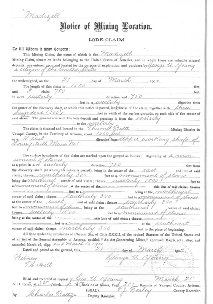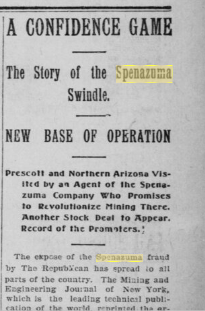
A confidence game: The Story of the Madizelle swindle. Base of operation, The (former) Derby Mining Company, Prescott Arizona Yavapai County. The original Notice of mining location for the Madizelle lode, located by George U. Young on March 21, 1902, recorded the same day at 3:35pm.
The notice states the claim is a full sized 1500’ x 600’ lode running 750’ east/west from the discovery shaft. Situated about 1000 feet northeast from the upper working shaft of Lowry-Hill Mine No. 1. There is no mention of any other claims around this, or connecting to this claim, like say the soon to be parallel the original Derby or even Derby 3, and Ellen 1 &2 from January 1902, in any way, just the 1000’ reference to the Lowry-Hill Mine No. 1 and it’s ‘upper’ working shaft.
This may be self explanatory by now, but let’s just picture the Madizelle here alone by itself and the nearest claim to identify with the mining district of thumb butte this side of the Willow Creek is the Lowry-Hill group a mere 1000’ away.
The original 1902 configuration per the prospectus of the Derby Mining Company and associated so called ‘map’ identified some of these same mineral survey 2424 Sheet 2 claims in a similar fashion. This ‘Prospectus‘ was scheme one…This would be effectively, scheme two:
If you take the Derby Mining Company’s prospectus ‘grouping of claims’ and turn it 90 degrees to the right, ignore the last chance, the railroad, and prescott, who cares where north is, slide Derby No. 3 to the side, relocate an Ellen No. 2 away from it’s crooked lode, place it where there is no lode, squeeze in a little ‘Madizelle’ in the middle, add a ‘Patsy’ on top where Willow Creek should be, make Willow Creek magically disappear, lay down a ‘Sunny Side’ overlap and wish away some other guys placer claim, forget all about the main shaft and shared lode vein of the Accidental that connects with the Derby, that is also the Derby lode vein to shaft, sprinkle on some dust, and you end up with Mineral Survey 2424 ‘Sheet 2’. A fairy tale, one that is contagiously contiguous with the Lowry-Hill, or the ‘claims’ of Mineral Survey 2424 ‘Sheet 1’.
Did the Ellen No. 2 relocate a lode on top of placer ground? Did the Ellen No. 1, Derby and Derby No. 2 ditch their original main lode/vein altogether? What about that main shaft on the Derby claim? What happened to it?
What’s even more odd, is the theoretical section corner calculations and numbered sections. They contradict the direction of the claims.
George U. Young could not call the Madizell nearby claim anything other than the Lowry-Hill that is was at this time. Negotioins were still ongoing with E.M. Sanford, James Lowry and Samuel Hill, Sarano, and Sharpneck. Later this same year, you will find the references all begin to follow ‘a future plan’.
To put this into a better perspective, all of these full sized claims are being danced around like floating claims within only about 1-2 square miles of T14N R3W, until the process to perpetuate the final chapter begins.
The remaining claims were simply drawn in around the Madizelle lode to make the contiguous depiction of having all the George U. Young fictions come together to comply with the unwritten and written letters of the G.L.O in the early 1900’s, otherwise risk ‘patent application denial’. It was a future plan for gaining title to the ground applied for. Young needed the others out of the way to perfect his final act, bought and paid, they all complied -willingly complied with the scheme to loot the public domain.
If you change the lode or discovery or centerline, and outiside the original ground, you change the claim itself. You don’t amend the original claim location, you effectively would need a formal relocation, or an entirely new Notice of claim location, without interfering with any rights of others in order to be effective. And all of course on open, available ground.
M.S. 2424 represents a mixed bag of tricks.
The field notes of M.S. 2424 list a reduction in surface area for the Ellen No. 2, due to the conflict shown on Plat with the Madizell. While highlighting the small area inside the bold lines as field notes report to be only .214 acres, it ignores the remainder of what should be the true length of the Madizelle claim, that was truncated by Fisher to the side line of Ellen No. 2, but not actually, if Fisher is acknowledging the conflict, he should be acknowledging the entire conflict, but does not.
The twist is the Ellen No. 2 would have senior right, as it was located and recorded in 1902, before the Madizelle was located and recorded. Although both located by George U. Young, the entire conflict is fictional in nature. The Ellen No. 2 did not relocate to conflict with the Madizelle, neither did the others.