Highland Park, AZ ‘Yavapai County will be well represented in the edition as Mr. Young wields a facile pen.’ ‘Geo. U. Young is back in town again. Mr. Young, in addition to his business as mining sale... Highland Pines Prescott, ArizonaMar 30, 2023Oct 4, 2023
Highland Park, AZ Dummy Locator: ‘..concealed interests, fraudulent locations, invalid in its entirety’ “If a locator has knowledge of a concealed interest and is a party to the use of dummy... Highland Pines Prescott, ArizonaMar 30, 2023Oct 4, 2023
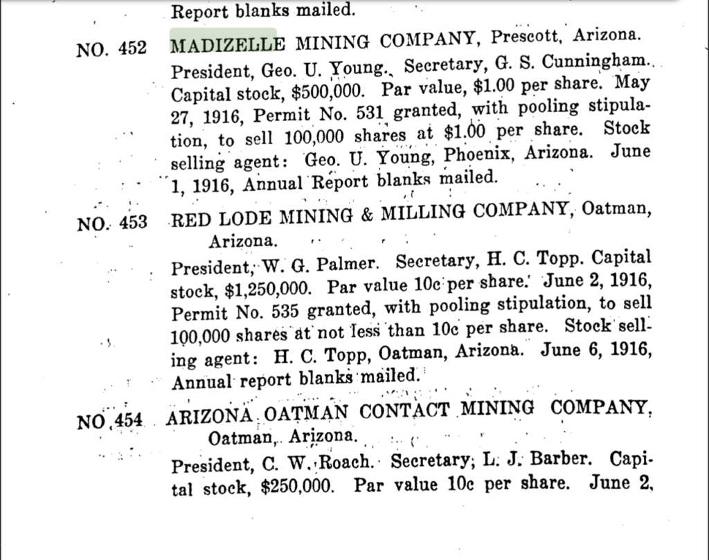
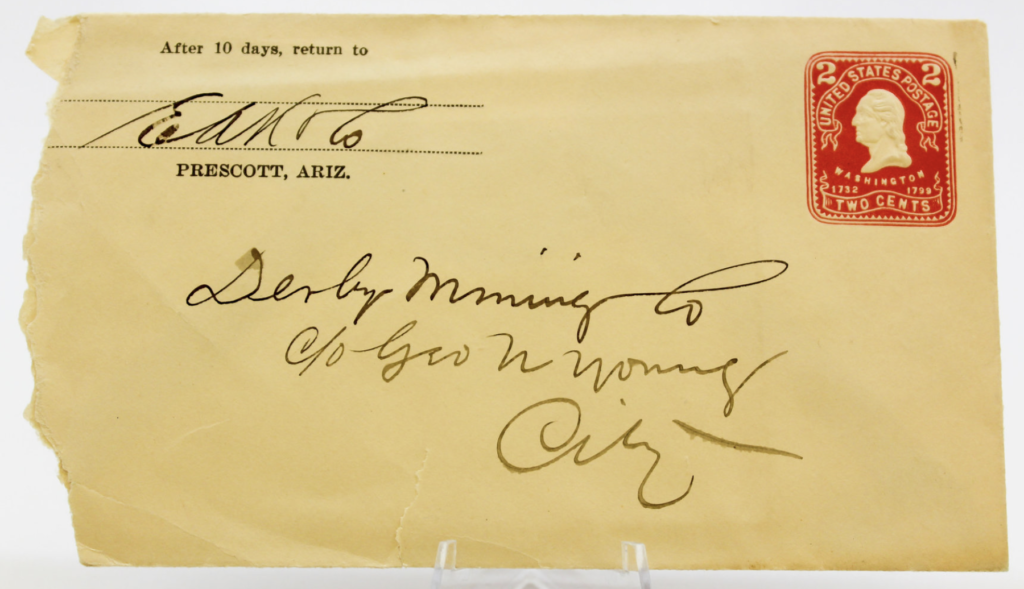
Highland Park, AZ Prospectus: Madizelle Mining Company’s property, 1917 In the letter below from F.J. Kilner at the Empire State Building in Spokane Washington, dated May 14,... Highland Pines Prescott, ArizonaMar 30, 2023Oct 4, 2023
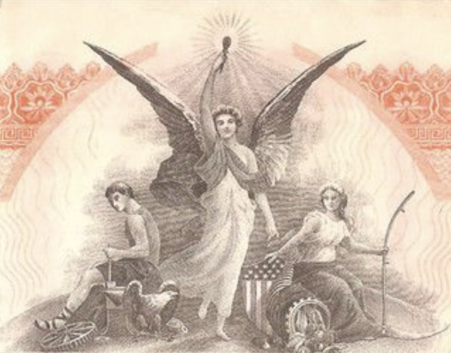
Highland Park, AZ ‘…Charged, in furtherance of said alleged conspiracy…’ $1000 bills Highland Pines Prescott, ArizonaMar 30, 2023Mar 30, 2023
Highland Park, AZ Skirts Clean of any Scandal of Dishonest Promotion The editor and publisher of Yavapai Magazine July 8th 1916 identifying the connection to the Madizelle Mining Company... Highland Pines Prescott, ArizonaMar 30, 2023Oct 4, 2023
Highland Park, AZ Arizona ‘Mineral Surveys’ A list of some very interesting records to pay special attention to, Mineral Surveys in Arizona from the... Highland Pines Prescott, ArizonaMar 29, 2023Mar 29, 2023
Highland Park, AZ Little Daisy- Jerome, J.J Fisher’s ‘Discovery’ The article below from the Arizona Weekly Journal Miner dated January 10th, 1900, just about sums it all... Highland Pines Prescott, ArizonaMar 29, 2023Mar 29, 2023
Highland Park, AZ Land Conscience: The ‘Missing’ Mineral Surveys of Arizona Missing Mineral Surveys Notes & Plats (Bureau of Land Management February 1st 1986) Arizona Highland Pines Prescott, ArizonaMar 27, 2023Oct 4, 2023
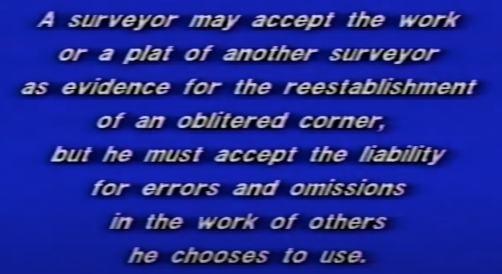
Highland Park, AZ Actual Positions vs. Theoretical Positions: Lode Mining Claims Highland Pines Prescott, ArizonaMar 26, 2023Oct 4, 2023
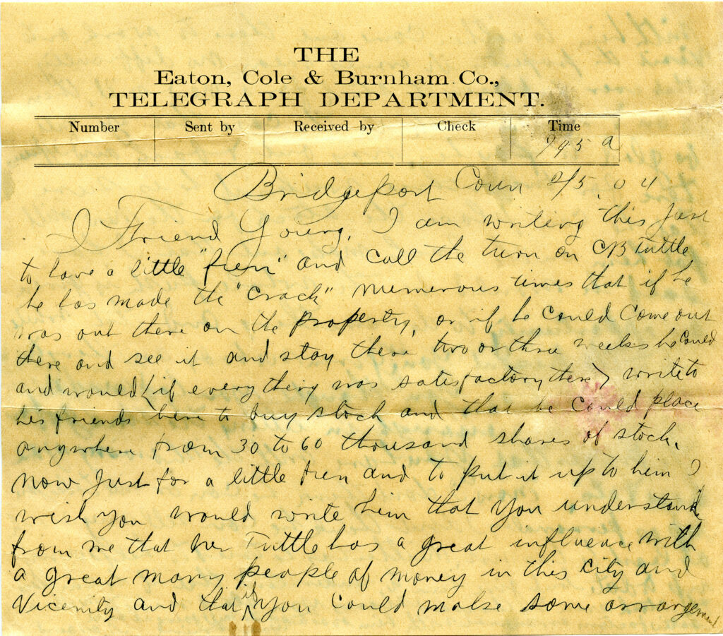
Highland Park, AZ Mining the Investor: Remarkable Stock Sale Offer The Arizona Republican, Wednesday Morning, June 14, 1916 A Clear Statement of the Remarkable Stock Sale Offer of... Highland Pines Prescott, ArizonaMar 26, 2023Oct 4, 2023
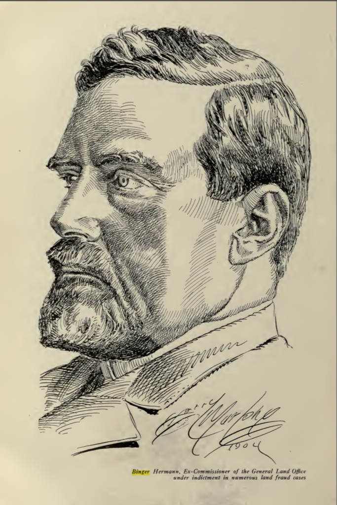
Highland Park, AZ Excerpt from James Underhill’s book: ‘Mineral Land Surveying’ 1906 TRACTING-Binger Hermann Policies: Highland Pines Prescott, ArizonaMar 26, 2023Oct 4, 2023
Highland Park, AZ Record of Survey 2022: Highland Pine Properties “This is not an ALTA/NSPS Land Title Survey…” 2022-0025457 Unbelievable. The very first part on the face of this drawing of survey done in 2022 is... Highland Pines Prescott, ArizonaMar 25, 2023Mar 25, 2023
Highland Park, AZ Mineral Survey MS2950 Yavapai County ‘GOLD STAR’ Lode Claim, Sections 31 & 36 T14N, R’s 3 &4W What a fine specimen we have here! The Gold Star Lode claim Mineral Survey 2950 in Yavapai County... Highland Pines Prescott, ArizonaMar 24, 2023Oct 4, 2023
Highland Park, AZ Mineral Survey 2730: ‘Cancel Others’ Logan Copper Company, Yavapai County, J.J. Fisher, Frank Ingalls 1909 Yet another shining example of a Yavapai County Mineral Survey No. 2730. Here we have the PLAT of... Highland Pines Prescott, ArizonaMar 24, 2023Oct 4, 2023
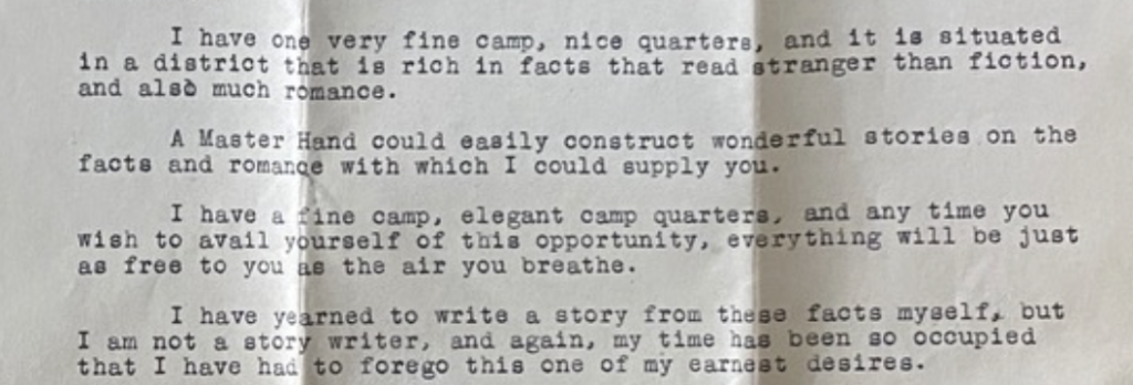
Highland Park, AZ Geo U. Young/ Madizelle 1924: ‘tampering with the laws of nature’ Master Hand Letter from the office of George U. Young to Zane Grey dated December 19, 1924 on... Highland Pines Prescott, ArizonaMar 24, 2023Oct 4, 2023
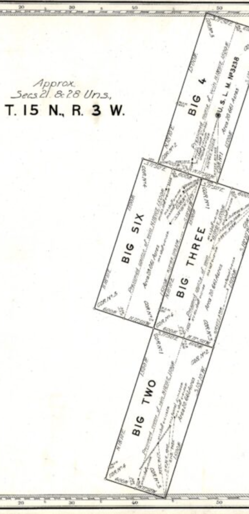
Highland Park, AZ ‘Presumed’ Course off Vein, ‘Approximate’ Sections 21 & 28 ‘Unsurveyed’ T15N R3W Merritt/ Frank Ingalls 1916 Yavapai Where is this? Highland Pines Prescott, ArizonaMar 24, 2023
Highland Park, AZ Blunders upon blunders of Fairy Dust The first of many, Highland Pine Properties subdivision PLAT A from October 1955 Yavapai County Arizona, with indication... Highland Pines Prescott, ArizonaMar 24, 2023Oct 4, 2023
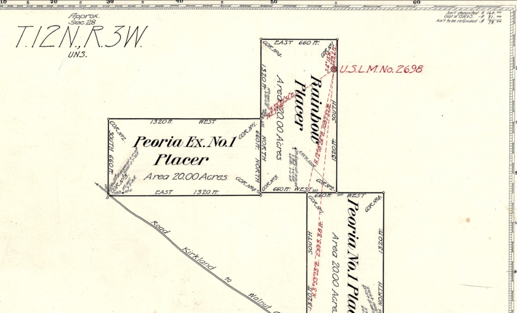
Highland Park, AZ ‘Relinquished’ MS2698 J.J. Fisher, Frank Ingalls Yavapai County 1909, Patent 07108 Mineral Survey MS2698 by J.J. Fisher -U.S.D.M.S. and approved by Frank Ingalls -Surveyor General for Arizona District, 1909.... Highland Pines Prescott, ArizonaMar 24, 2023
Highland Park, AZ MS1718 ‘Surprise’ J.J. Fisher Prescott, AZ Lode ‘Claims’ Section 11 From Corner No. 1 Surprise No. 2: S. 16 Degrees 06 W 6701.0 Ft. to Original Corner of... Highland Pines Prescott, ArizonaMar 24, 2023Oct 4, 2023
Highland Park, AZ J.J. Fisher U.S.D.M.S., James R. Lowery Mineral Survey 1550 PINE SPRING Where is this? Highland Pines Prescott, ArizonaMar 24, 2023Oct 4, 2023
Highland Park, AZ Yavapai County Arizona 1903 Ernest A Haggott, M.E. and Chas M. Richards, Eng. 1903 Map of Yavapai County Arizona Highland Pines Prescott, ArizonaMar 24, 2023Mar 24, 2023
Highland Park, AZ ‘Original Surveys’ :…’eliminated incentives that encouraged fraud and corruption.’ From the U.S. Department of the Interior Bureau of Land Management module on ‘Original Surveys’: The Interior Department... Highland Pines Prescott, ArizonaMar 24, 2023Oct 4, 2023
Highland Park, AZ S.W. Foreman: Township 14 N Range 1,2,& 3 G.S.R.M. ‘Surveyed’ August 1-11 1871 Quite an amazing feat by U.S. surveyor S.W. Foreman to cover such a large area of land, all... Highland Pines Prescott, ArizonaMar 24, 2023Oct 4, 2023
Highland Park, AZ George U. Young’s Patenting of MS2424 Claims: Madizelle Mining Co./ George U. Young ” I went down to Hildreth’s office this morning in regard to the patent, and xxxx said he... Highland Pines Prescott, ArizonaMar 23, 2023Oct 4, 2023
Highland Park, AZ ‘Snapping’ Mining Claims to Section Corners Highland Pines Prescott, ArizonaMar 23, 2023Oct 4, 2023
Highland Park, AZ Highland Park, AZ Thumb Butte Mining District B.L.M. ‘Master Title Plats’ This is the filed original Master Title Plat of record with the Arizona Bureau of Land Management for... Highland Pines Prescott, ArizonaMar 23, 2023Oct 4, 2023
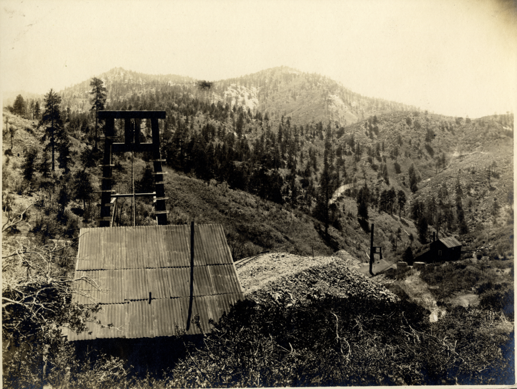
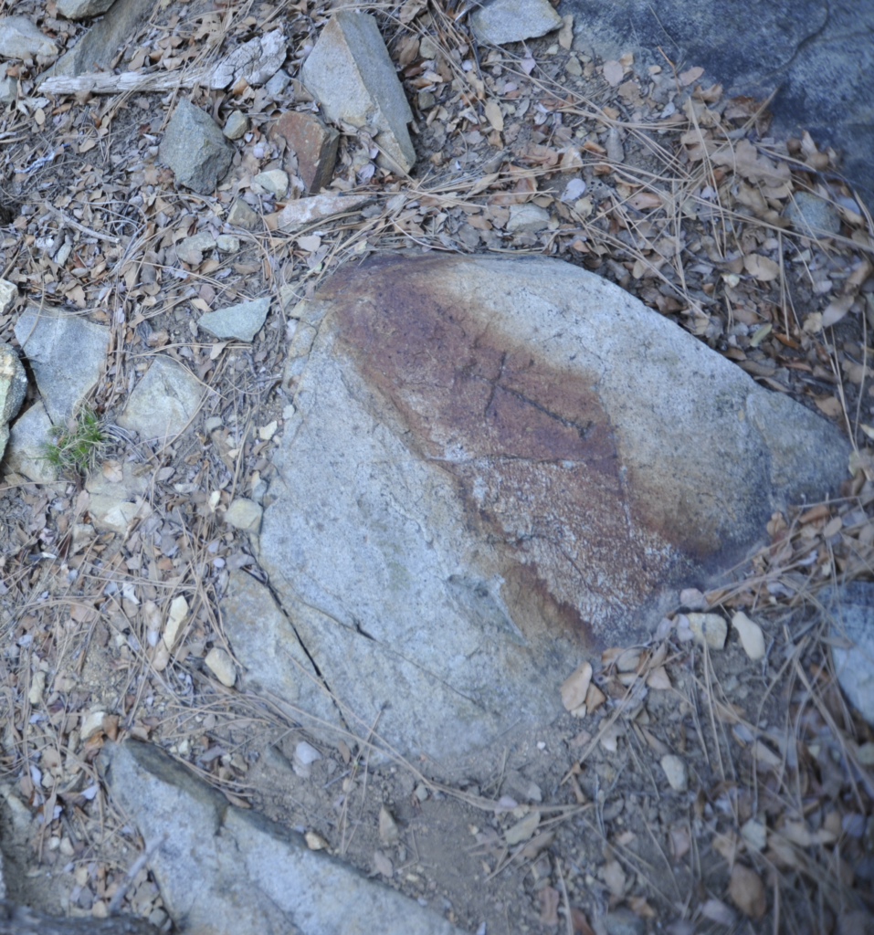
Highland Park, AZ Upper Working Shaft (Not Italian): On Windy Ridge Dr @ ‘Horse Corral’ near 1066 N. Skyline Drive A nice rock pile and ‘upper working shaft’ beside the home at 1066 N. Skyline Drive in Prescott,... Highland Pines Prescott, ArizonaMar 23, 2023Oct 4, 2023
Highland Park, AZ Madizelle: Notice of Mining Location March 21, 1902 The claim is situated and located in the Thumb Butte Mining District In Yavapai County, In the Territory... Highland Pines Prescott, ArizonaMar 22, 2023Oct 4, 2023
Highland Park, AZ Township 14 North Range 4 West GSRM, S.W. Foreman, John Wasson -Surveyor General 1875 General Land Office plat of record for the Township 14 North Range 4 West in the Gila and... Highland Pines Prescott, ArizonaMar 22, 2023Oct 4, 2023
Highland Park, AZ Corner to Sections 28-27-33-34, S.W. Foreman 1871, Township 14North, Range 3 West So the tale starts something like this: There once was a survey….in the area west of Prescott Arizona... Highland Pines Prescott, ArizonaMar 21, 2023Mar 21, 2023
Highland Park, AZ Madizelle Mining Company: Arizona Magazine From ARIZONA magazine: “In this issue will be found the stock offering of the Madizelle Mining Company, designated... Highland Pines Prescott, ArizonaMar 21, 2023Apr 16, 2023
Highland Park, AZ Cancelled: Mineral Survey MS1577, J.J. Fisher Yavapai County Black Hills Mining District 1902 Just one example of the plethora of problematic & administratively cancelled Mineral Survey Plat’s of this era. There... Highland Pines Prescott, ArizonaMar 20, 2023Oct 4, 2023
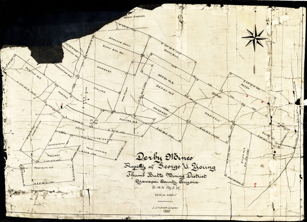
Highland Park, AZ Pretty Looking ‘Maps’ of the General Land Office Derby Mines The drawing above is likely a preliminary version of what became U.S. Mineral Survey 2424. What... Highland Pines Prescott, ArizonaMar 20, 2023Oct 4, 2023
Highland Park, AZ George U. Young’s ‘Mammoth Mines’, Youngberg, Arizona, ‘Goldfield’: MS1130 & MS3886 -CANCELLED Cancelled notations by the Arizona State director’s on the face of the original 1894 Plat of the Claim... Highland Pines Prescott, ArizonaMar 19, 2023Oct 4, 2023
Highland Park, AZ Pyriten: A ‘glib entrepreneur with unbounded optimism’ Arizona Mining Scams and Unassayable Ore Projects of the Late 20th Century by W. Scott Donaldson, dated December... Highland Pines Prescott, ArizonaMar 19, 2023Oct 4, 2023
Highland Park, AZ How to Correctly Interpret the Fictitious and Falsified Plat and Field Notes Returned By the U.S. Deputy Mineral Surveyors: Knocker Hermann Aha…a clear and present ‘cloud on the monuments‘ themselves. Highland Pines Prescott, ArizonaMar 19, 2023Oct 4, 2023
Highland Park, AZ Four White Socks: Where on Earth is this place? Highland Pines Prescott, ArizonaMar 19, 2023Oct 4, 2023
Highland Park, AZ Fool me once…. Information required when considering the purchase of mining properties...or the purchase of ‘stock’ in fairy dust factories. This... Highland Pines Prescott, ArizonaMar 19, 2023Oct 4, 2023
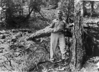
Highland Park, AZ Joseph ‘Joe’ Dougherty’ Puritan Mine, Indiana Group Highland Pines Prescott, ArizonaMar 19, 2023Oct 4, 2023
Highland Park, AZ 1871 Standard Lines, Township Exteriors ARIZONA S.W. Foreman, John Wasson -Surveyor General A very interesting illustration of official record that identifies the Arizona territorial plat of standard lines and township... Highland Pines Prescott, ArizonaMar 19, 2023Oct 4, 2023
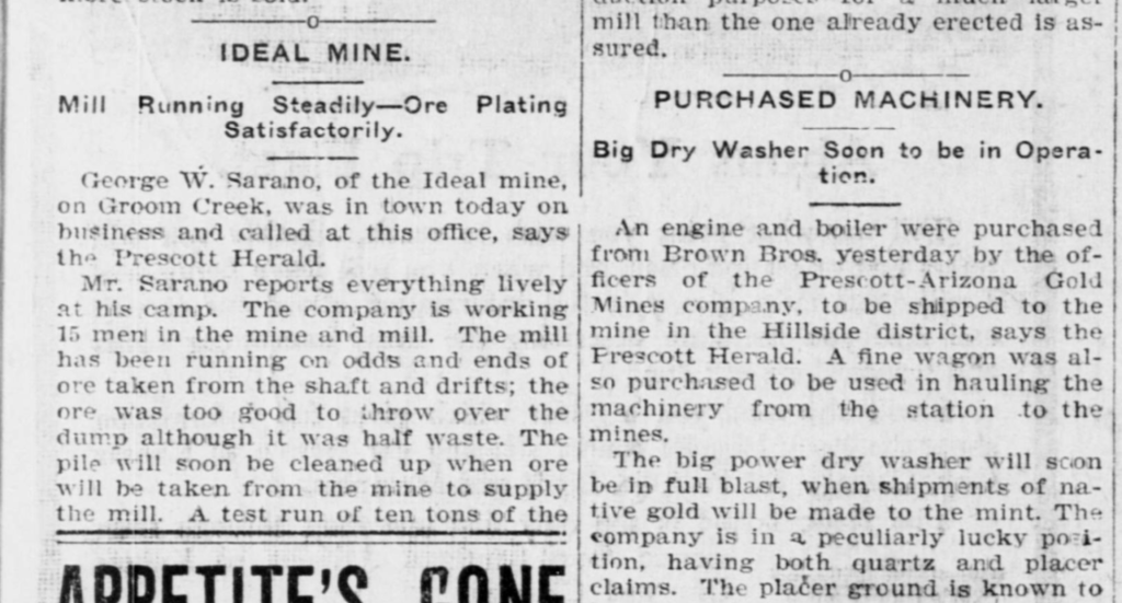
Highland Park, AZ George W. Sarano, Swindler: Ideal Mining Company, Prescott AZ Now why would anyone bring a bar of Gold into the town of Prescott worth $400 in 1901?... Highland Pines Prescott, ArizonaMar 19, 2023Oct 4, 2023
Highland Park, AZ Records Vs. Monuments: ‘the records……are made up’ -The Mining Reporter December 10, 1903 Highland Pines Prescott, ArizonaMar 19, 2023Oct 4, 2023
Highland Park, AZ Ace in the Hole: MS1397 A & B 1899, J.J Fisher John ‘J/J/’ Fisher’s Last Chance Lode and Mill-site, Prescott Arizona, Yavapai County October 27 1899 Mineral Survey 1397,... Highland Pines Prescott, ArizonaMar 18, 2023Oct 4, 2023
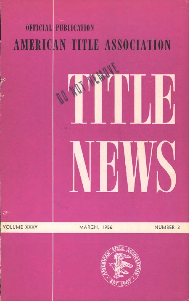
Highland Park, AZ Highland Pines Plat “E” a Portion of Mineral ‘Survey’ NO. 2424: yeah…but not really. American Title Association Est. 1907, Volume XXXV Number 3, March 1956 Highland Pines Prescott, ArizonaMar 18, 2023Oct 4, 2023
Highland Park, AZ Norman Hale: ‘IONA’ Notice of Mining Location/ Lode Claim The Iona lode claim (Statutes of Iona) Notice of Mining Location, entered upon and located for the purpose... Highland Pines Prescott, ArizonaMar 16, 2023Oct 4, 2023
Highland Park, AZ Ellen No. 1 Lode Claim-Between End Monuments-Northerly and Southerly 750/750 Highland Pines Prescott, ArizonaMar 16, 2023Oct 4, 2023
Highland Park, AZ Binger Hermann Policy Problems: Corrections, D.O.I. Decisions And a third situation is where there appears to be a conflict, but there is no conflict, the... Highland Pines Prescott, ArizonaMar 16, 2023Oct 4, 2023
Highland Park, AZ Townships 14 North Range 3 West, 13 North Range 3 West, Original Survey Plat 1871 Yavapai County Arizona Original Plat Map Survey 1871, Township 13 North Range 3 West Highland Pines Prescott, ArizonaMar 16, 2023Oct 4, 2023
Highland Park, AZ Executive Order: Revocation, Withdrawing Public Lands in T14N, R3W G.S.R.B.M., Franklin D. Roosevelt January 25, 1936 Highland Pines Prescott Arizona in Township 14N, Range 3 West Yavapai County Highland Pines Prescott, ArizonaMar 15, 2023Oct 4, 2023
Highland Park, AZ James R. Lowry: Yavapai County 1918 Highland Pines Prescott, ArizonaMar 15, 2023Oct 4, 2023
Highland Park, AZ Looters of the Public Domain: “First Be Sure You’re Right Then Go Ahead” Highland Pines Prescott, ArizonaMar 15, 2023
Highland Park, AZ Lowry-Hill 1896 Notice of Mining Location Quartz (Lode) Claim Original Notice of Mining Claim Location circa 1896, Yavapai Sheriff James R. Lowry (Lowery) and Thomas C. Hill.... Highland Pines Prescott, ArizonaMar 15, 2023Oct 4, 2023
Highland Park, AZ Protection – Notice of Mining Location – Lode Claim, Highland Pines – Prescott, Arizona ‘Protection’ Lode Claim of George U. Young existed of record prior to the Protection #2 and the Protection... Highland Pines Prescott, ArizonaMar 15, 2023Oct 4, 2023
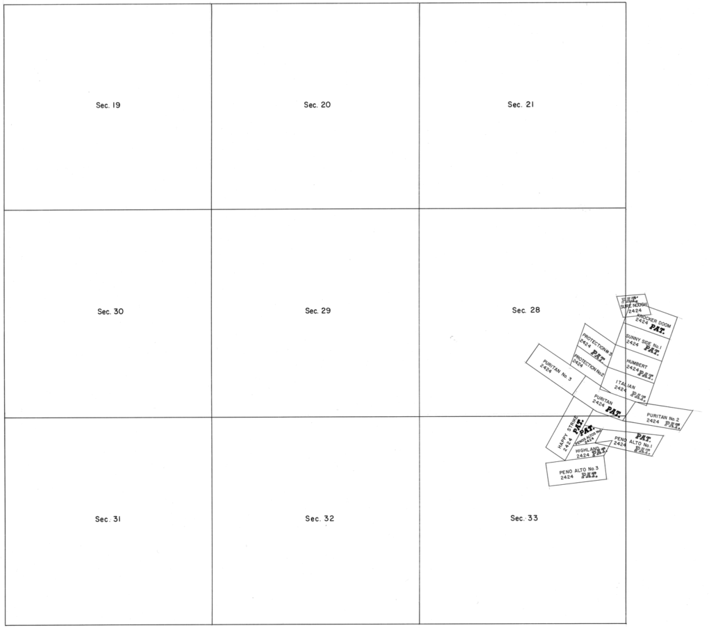
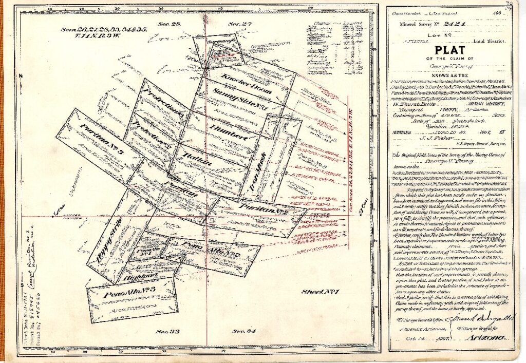
Highland Park, AZ Mineral Survey 2424 MS2424 Prescott, Arizona Yavapai County; ‘Highland Pines’ >Enter the Unicorn< The ‘PLAT’ shown above, Mineral Survey No. 2424, is fictitious. This is Sheet 1. See Sheet 2 below-... Highland Pines Prescott, ArizonaMar 14, 2023Oct 4, 2023
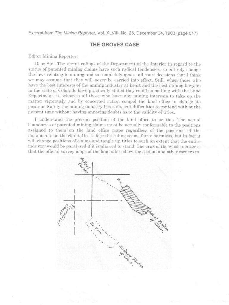
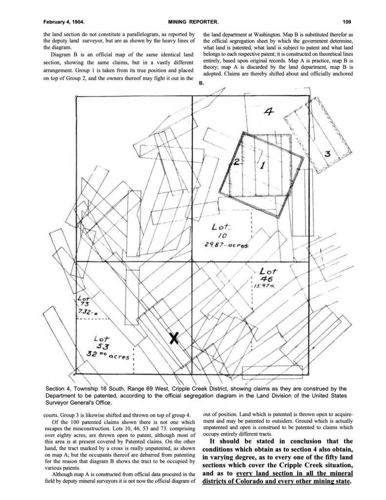
Highland Park, AZ The Mining Reporter 1903; The Groves Case, Theoretical Corners, Positions, Mining Claims Actual Corners v. Theoretical Corners Highland Pines Prescott, ArizonaMar 14, 2023Oct 4, 2023
Highland Park, AZ Madizelle Mining Company, 1908 Articles of Incorporation; ‘Philadelphia’ What happened to the Derby Mine? The name of the corporation is (now) Madizelle Mining Company. A serialized... Highland Pines Prescott, ArizonaMar 14, 2023Oct 12, 2023
Highland Park, AZ John Wasson, Surveyor General Land Office G.L.O. 1871, Arizona Territory: T14N Range 3 West G.S.R.B.M.: John Wasson, U.S. Surveyor General Arizona Territory 1871 The original Township 14 North Range 3 West Government Land... Highland Pines Prescott, ArizonaMar 14, 2023Oct 4, 2023
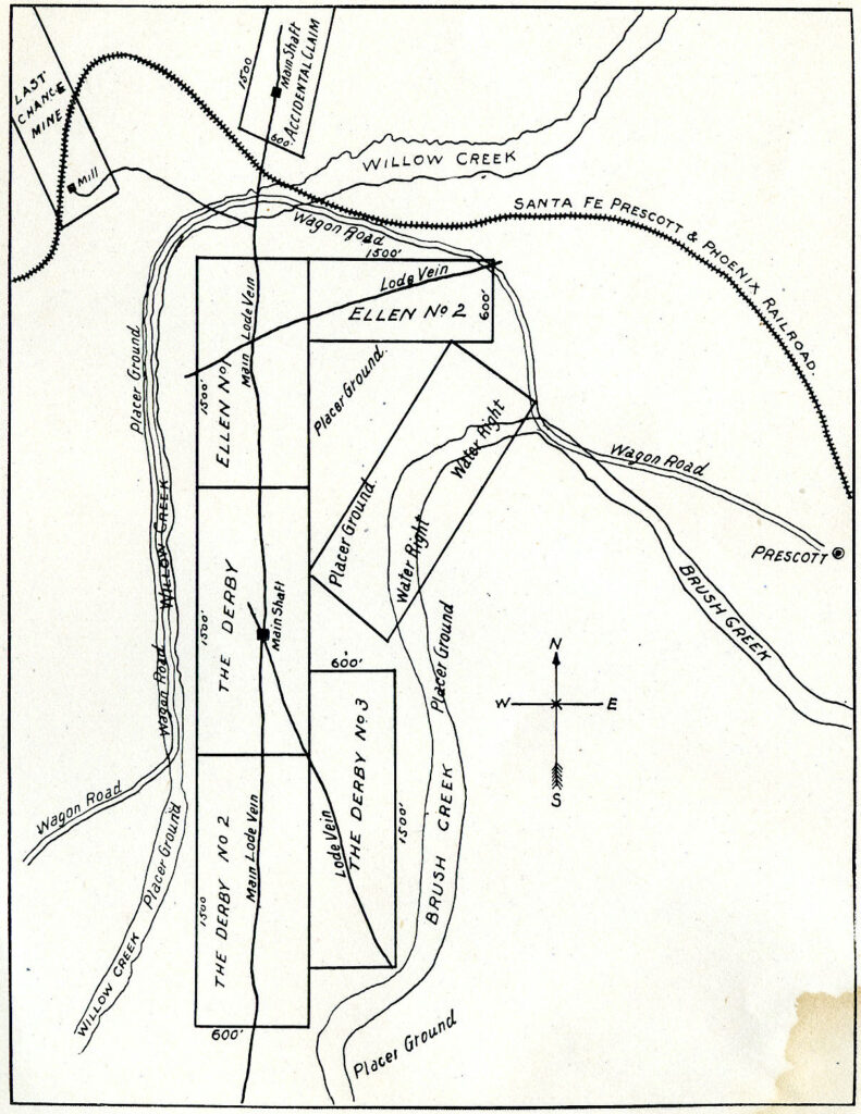
Highland Park, AZ Prospectus Map : Derby, Ellen, Last Chance, Accidental Lode Mining Claims North, South, East, West positions of the Derby Mine, Ellen Mine, Accidental Mine, Last Chance Lode Claims Prescott,... Highland Pines Prescott, ArizonaMar 12, 2023Oct 4, 2023
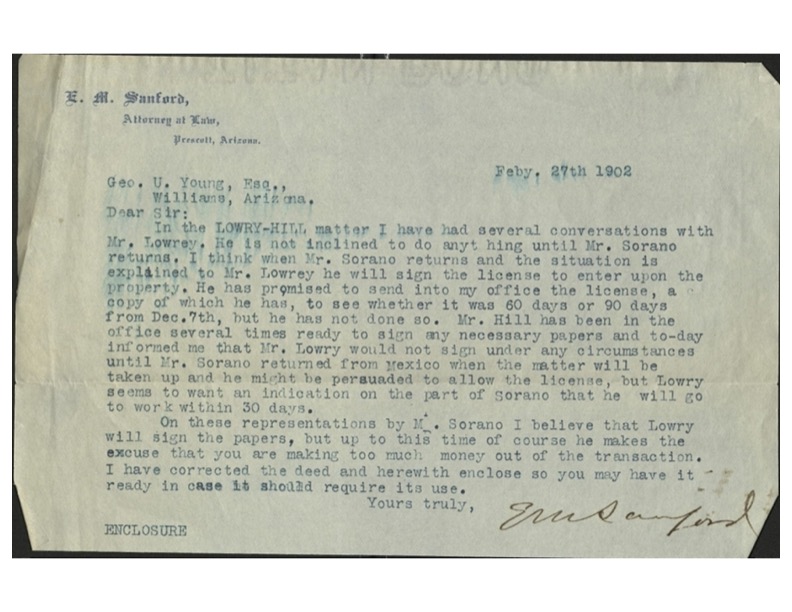
Highland Park, AZ E.M. Sanford letters re: Highland Pines land leased to George U. Young, Mr. Hill, James R. Lowery, E.L. Sharpneck, George W. Sarano Way before the concept for Highland Pines in the early 1950’s was ever a sparkle in the eyes... Highland Pines Prescott, ArizonaMar 12, 2023Oct 13, 2023
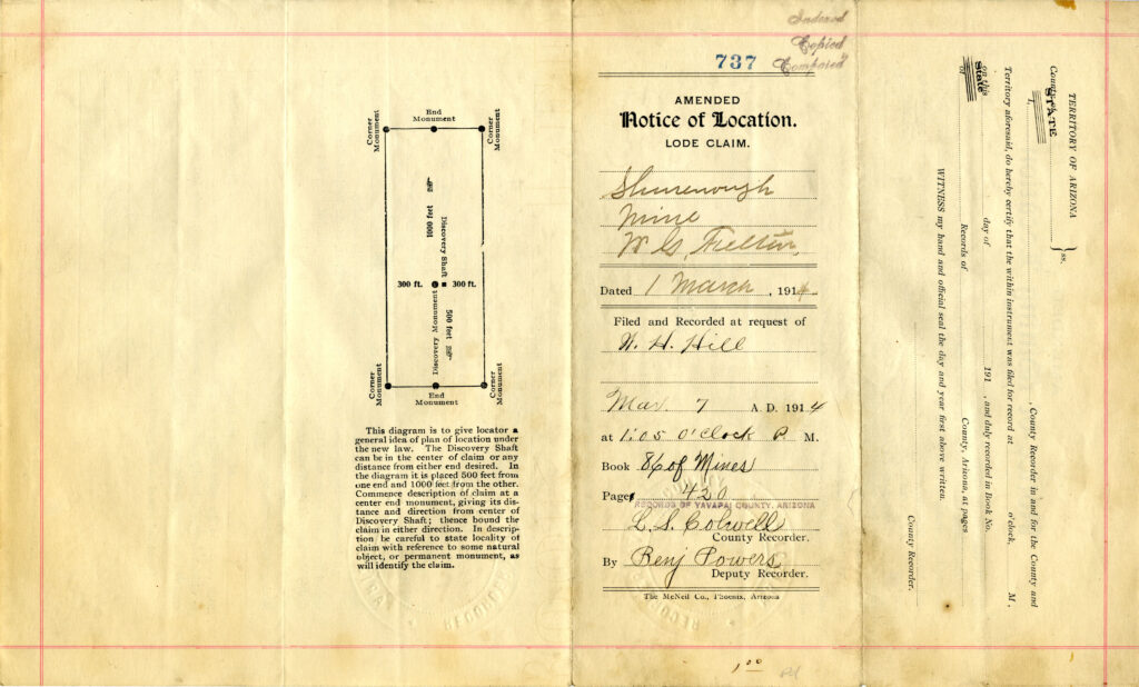
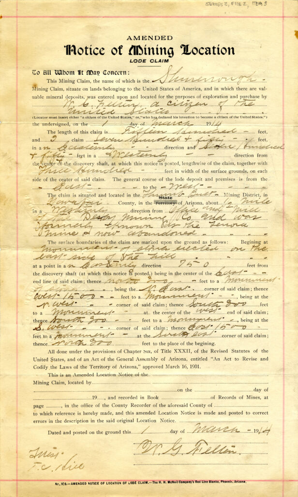
Highland Park, AZ Shurenough Lode Claim: March 1, 1914 Shurenough Lode Claim, Situated and Located ‘About a half mile in a westerly direction from office and mill... Highland Pines Prescott, ArizonaMar 12, 2023Oct 4, 2023
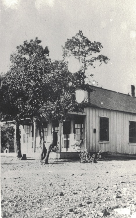
Highland Park, AZ Add Title That is the ‘title’ to this post. Prescott National Forest That’s it! That is the answer, the Prescott... Highland Pines Prescott, ArizonaMar 12, 2023Oct 4, 2023
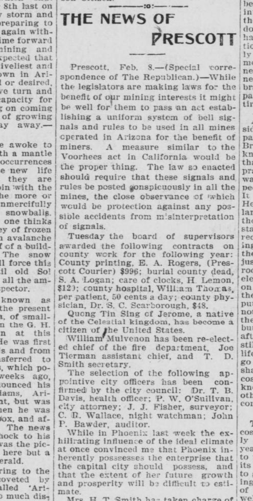
Highland Park, AZ Prescott City officer: J.J. Fisher, Surveyor Highland Pines Prescott, ArizonaMar 12, 2023Oct 4, 2023
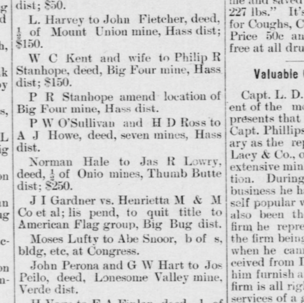
Highland Park, AZ James R. Lowry: deed 1/2 ‘Ohio MInes’ Highland Pines Prescott, ArizonaMar 12, 2023Oct 4, 2023
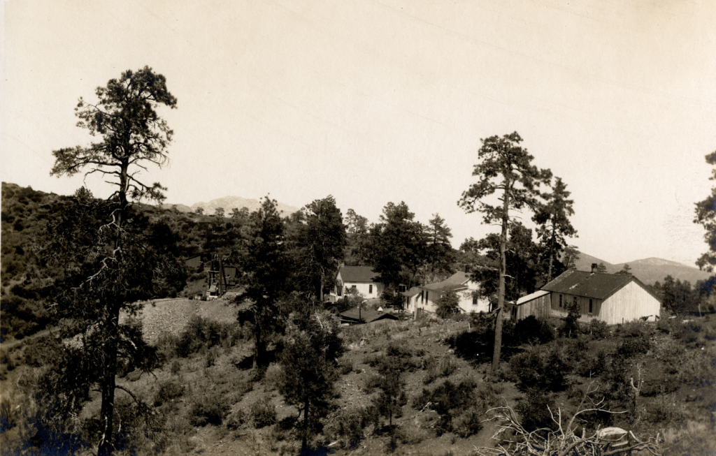
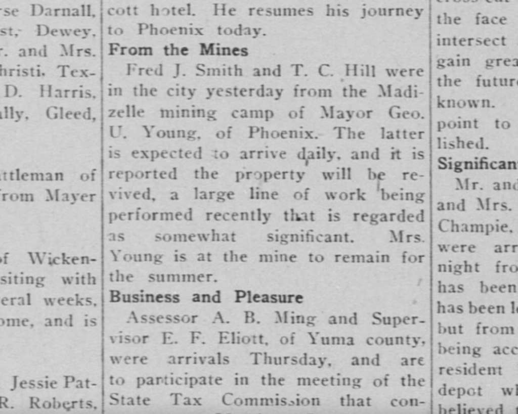
Highland Park, AZ T.C. Hill Camp, Ideal Camp, Lowry Camp, Derby Camp or Madizelle Mining Camp? Take your pick… From the Camp: Fred J. Smith did not exist at the property until late in 1911, when he... Highland Pines Prescott, ArizonaMar 12, 2023Oct 13, 2023
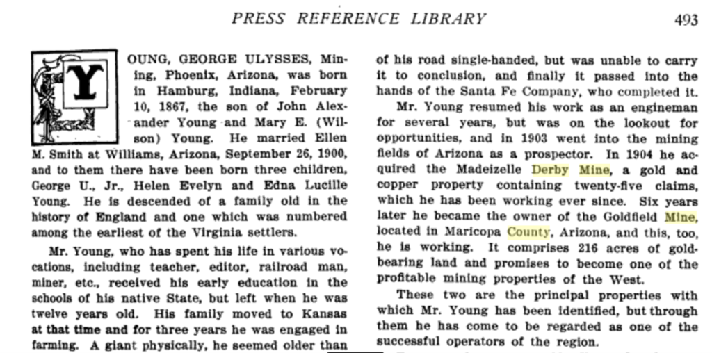
Highland Park, AZ George Ulysses Young, Prospector This is an inaccurate accounting of George U. Young’s mining affairs, the timeline and his role in the... Highland Pines Prescott, ArizonaMar 11, 2023
Highland Park, AZ George W. Sarano and the ‘Ideal’ connection Mr. George W. Sarano was a busy man in Prescott’s mining era. He was purportedly a Mining District... Highland Pines Prescott, ArizonaMar 11, 2023Oct 4, 2023
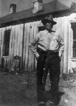
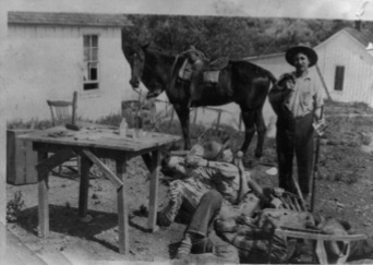
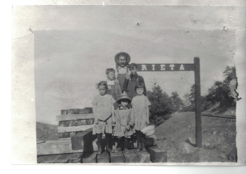
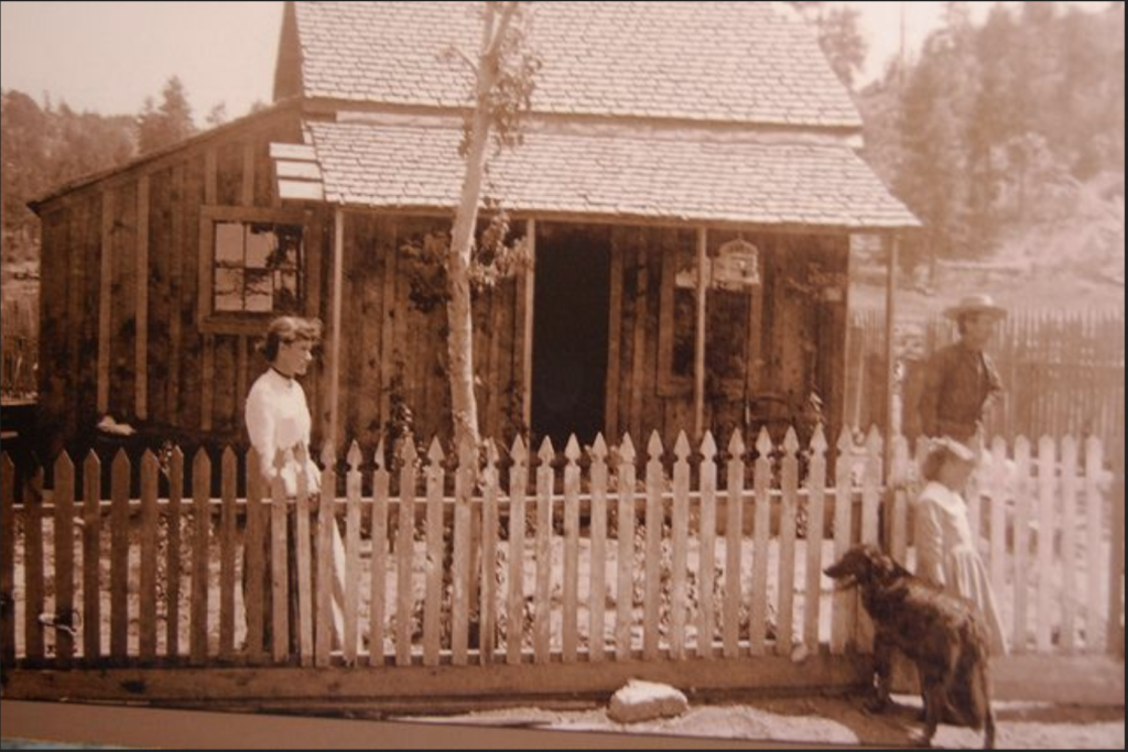
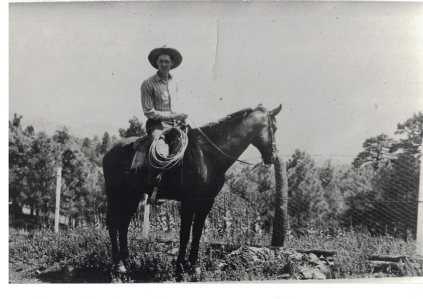
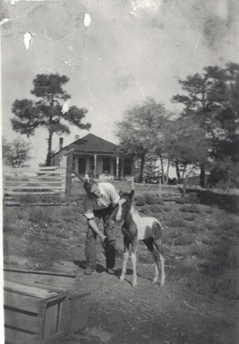
Highland Park, AZ The Original Cowboys of Highland Pines Highland Pines Prescott, ArizonaMar 11, 2023Oct 4, 2023
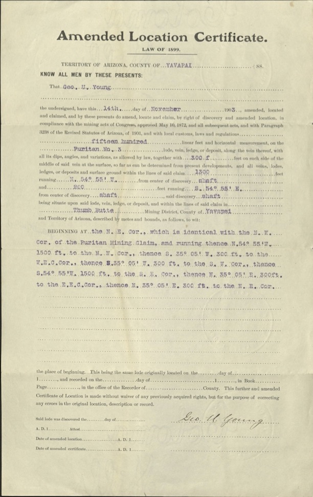
Highland Park, AZ Puritan NO. 3 Amended Location Certificate, Law of 1899, George U. Young 1903 The only certificate of record for the referenced Puritan No. 3 lode claim of U.S. Mineral Survey 2424,... Highland Pines Prescott, ArizonaMar 11, 2023Oct 4, 2023
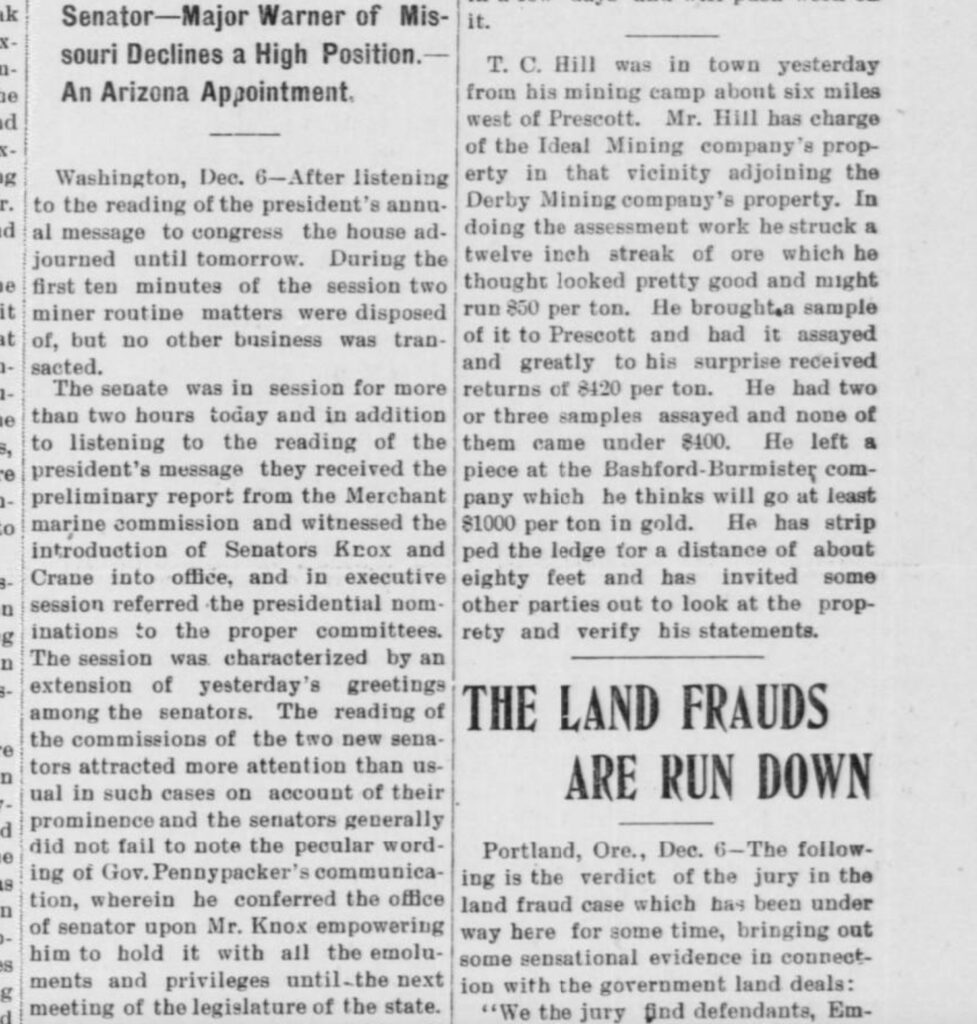
Highland Park, AZ The Ideal Mining Company’s Property: ‘about six miles west of Prescott’ The Land Frauds are Run Down… “T.C. Hill was in town yesterday from his mining camp about six... Highland Pines Prescott, ArizonaMar 11, 2023Oct 4, 2023
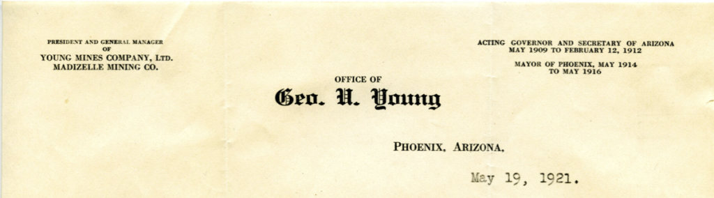
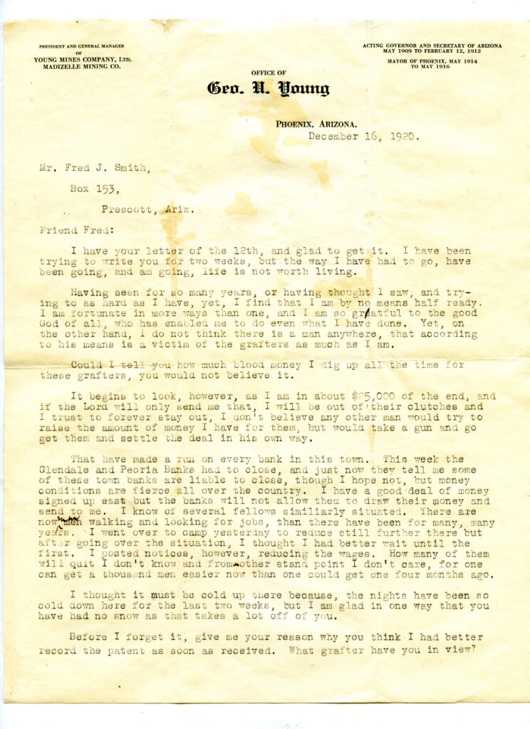
Highland Park, AZ Office of George U. Young: President and General Manager Young Mines Company Ltd., Madizelle Mining Co. Letter of December 16, 1920, to caretaker of the land Fred J. Smith at Prescott, during the land... Highland Pines Prescott, ArizonaMar 11, 2023Oct 4, 2023
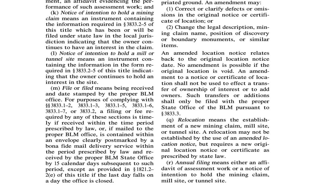
Highland Park, AZ AMENDED LOCATION NOTICES: (q) RELOCATION “An amended location notice relates back to the original location notice date. No amendment is possible if the... Highland Pines Prescott, ArizonaMar 11, 2023Oct 4, 2023
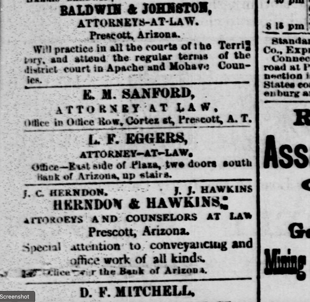
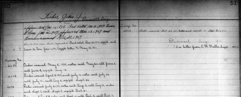
Highland Park, AZ John J. Fisher: United States Deputy Mineral Surveyor, Prescott, Arizona Appointment of John ‘J.J.’ Fisher, United States Deputy Mineral Surveyor Prescott Arizona. J.J. Fisher is one of the... Highland Pines Prescott, ArizonaMar 11, 2023Oct 4, 2023
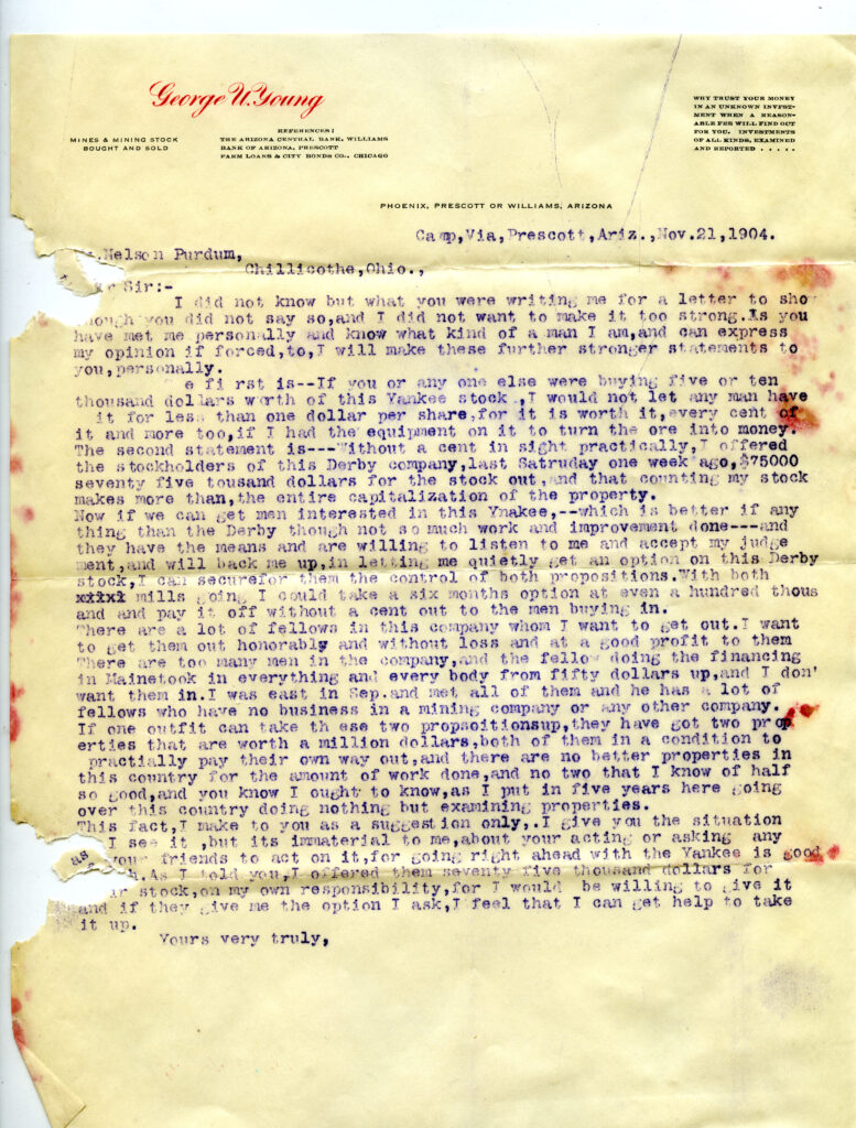
Highland Park, AZ George U. Young: Mines & Mining Stock Bought and Sold, 1904 Letter Mining the Investor letter dated November 21, 1904, from George U. Young via ‘Camp’ at Derby Mine stock,... Highland Pines Prescott, ArizonaMar 11, 2023Oct 4, 2023
Highland Park, AZ MS2424 Preliminary drawing 1907 J.J. Fisher: Property of George U. Young Thumb Butte District Derby Mines? So this is not a survey, but just a drawing of an idea for the future... Highland Pines Prescott, ArizonaMar 11, 2023Oct 4, 2023
Highland Park, AZ The Mining Reporter: 1903 the ‘Groves Case’ Assigned position, vs. actual (legal/monumented) positions on the ground. Vein vs. NO VEIN, tangling up titles. Highland Pines Prescott, ArizonaMar 11, 2023Mar 11, 2023
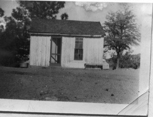
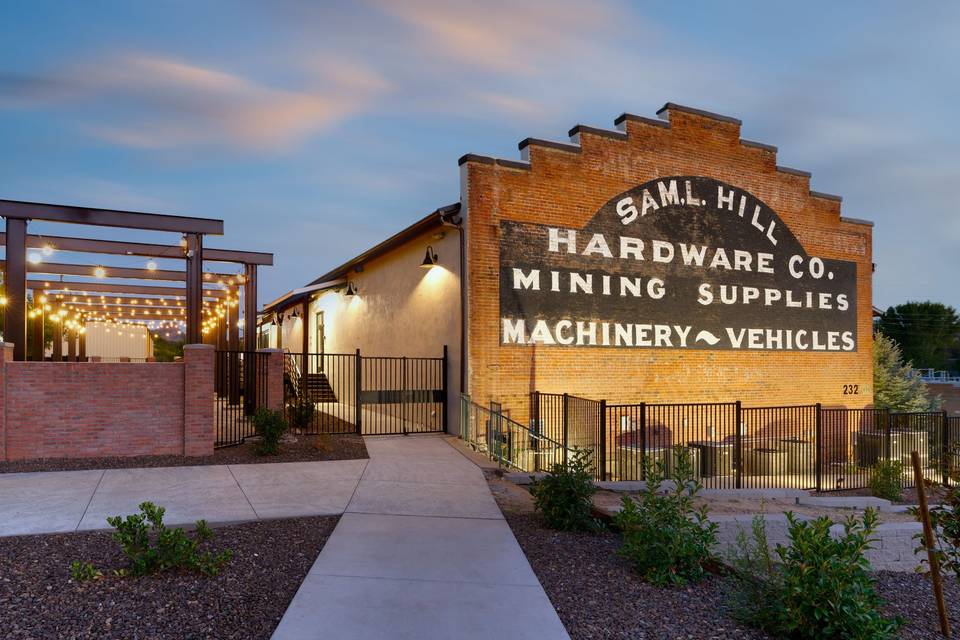
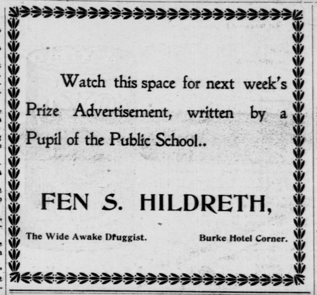
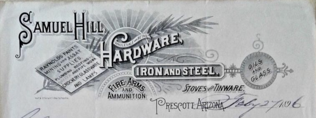
Highland Park, AZ Sam Hill Hardware Prescott, Arizona Yeah this one: Highland Pines Prescott, ArizonaMar 11, 2023Mar 11, 2023
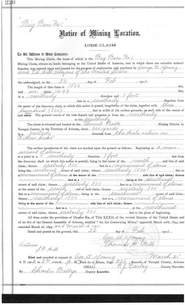
Highland Park, AZ Big Ben No. 1 & No. 2 Lode Claims, Notice of Mining Location: George U. Young and T.C. Hill recorded the above notice of mining location in 1902, in Yavapai County... Highland Pines Prescott, ArizonaMar 11, 2023Oct 4, 2023
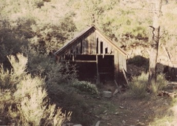
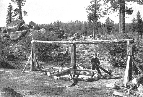
Highland Park, AZ Arrastra site Prescott, Arizona Highland Pines Prescott, ArizonaMar 11, 2023Oct 4, 2023
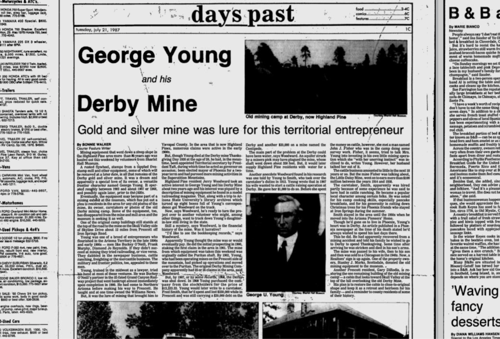
Highland Park, AZ George Young and his Derby Mine: Days Past, 1987 Highland Pines Prescott, ArizonaMar 11, 2023Oct 4, 2023
Highland Park, AZ Fake Gold Mines The Mining World: The images above were taken by a well known photographer in Prescott during the early... Highland Pines Prescott, ArizonaMar 11, 2023Oct 4, 2023
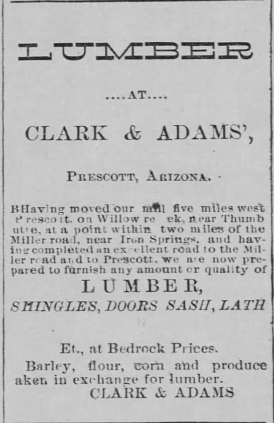
Highland Park, AZ CLARK & ADAMS Lumber yard and Saw Mill -the ‘Girl Scout’ property: CLARK & ADAMS Lumber and Saw Mill Site: The Clark and Adams saw mIll site and lumber yard... Highland Pines Prescott, ArizonaMar 11, 2023Oct 4, 2023
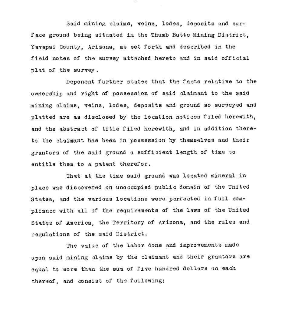
Highland Park, AZ Mineral Survey 2424, United States Patent Deed 818945 Application for Mineral Patenting language: “…As set forth and described in the field notes of the survey attached... Highland Pines Prescott, ArizonaMar 11, 2023Oct 4, 2023
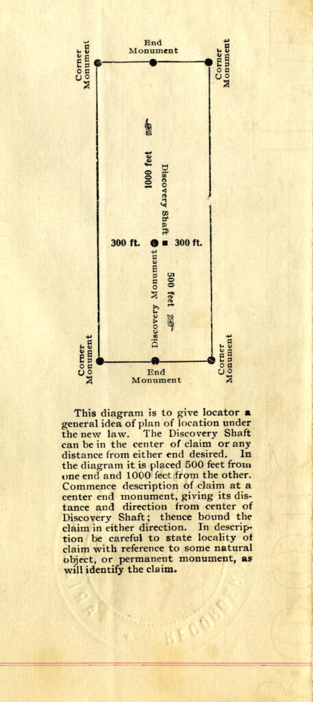
Highland Park, AZ Discovery Shaft of a Lode Mining Claim, Mining Claim Locations as Noticed: Highland Pines Prescott, ArizonaMar 11, 2023Oct 4, 2023
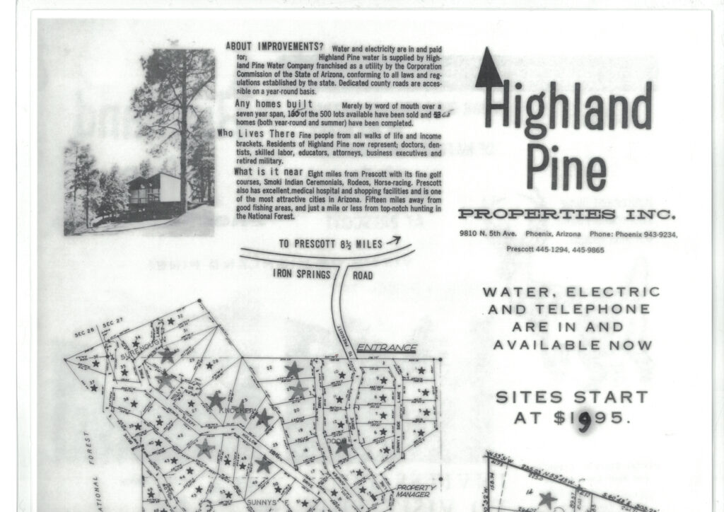
Highland Park, AZ Highland Pines Prescott Arizona, Highland Pine Properties Inc. Promotional Homesites Sales Flyer Standard homesites in Highland Pines Prescott Arizona, as platted, were originally sold for a mere $1495.00, later increasing... Highland Pines Prescott, ArizonaMar 11, 2023Oct 4, 2023
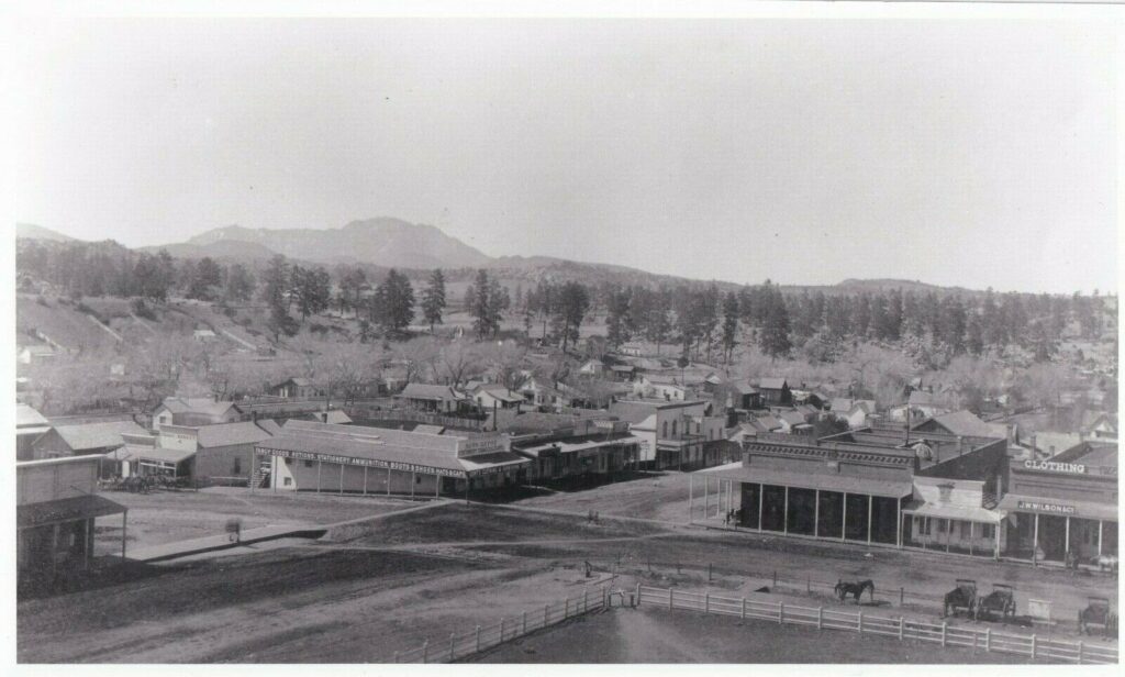
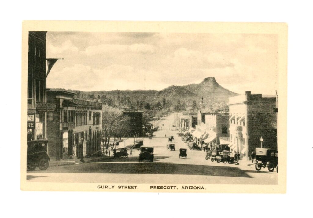
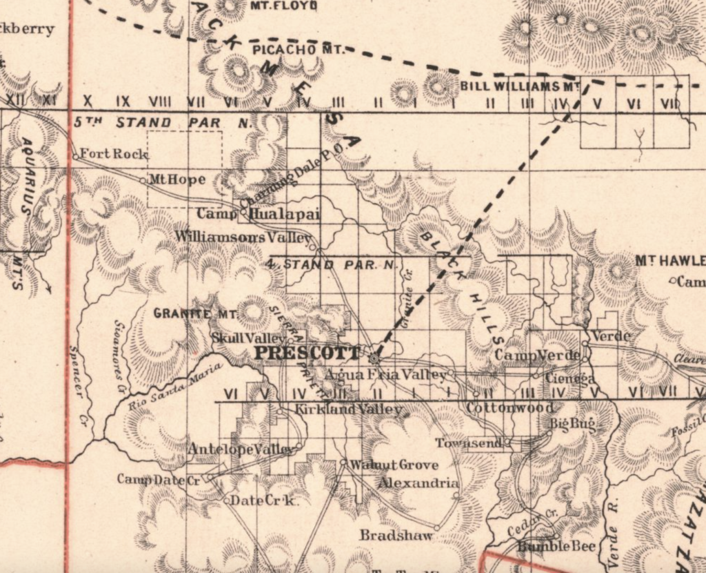
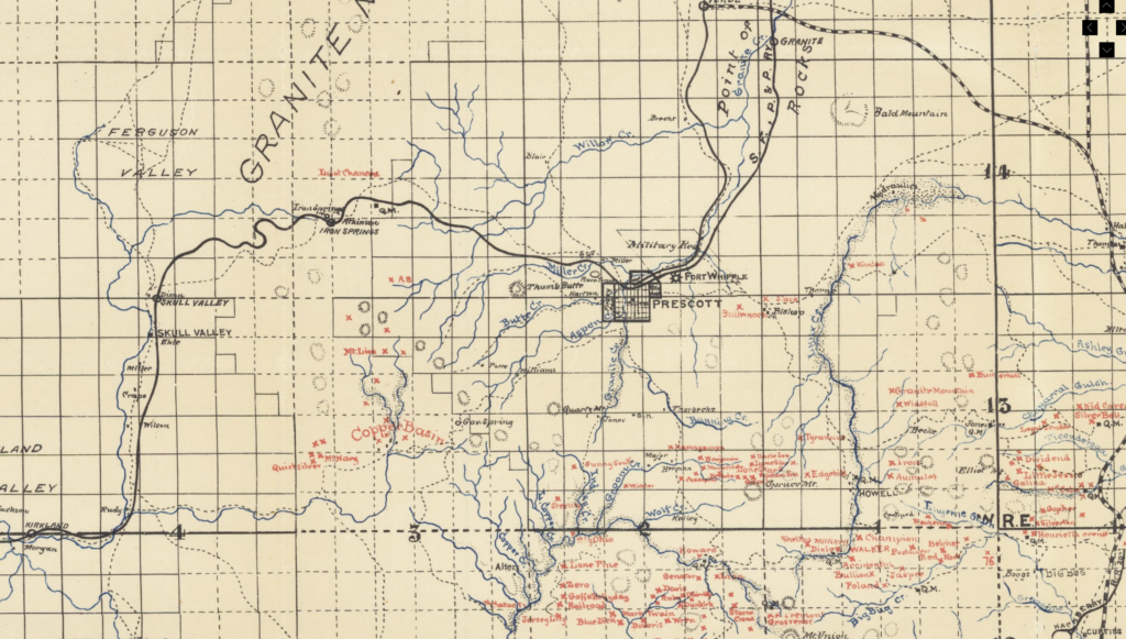
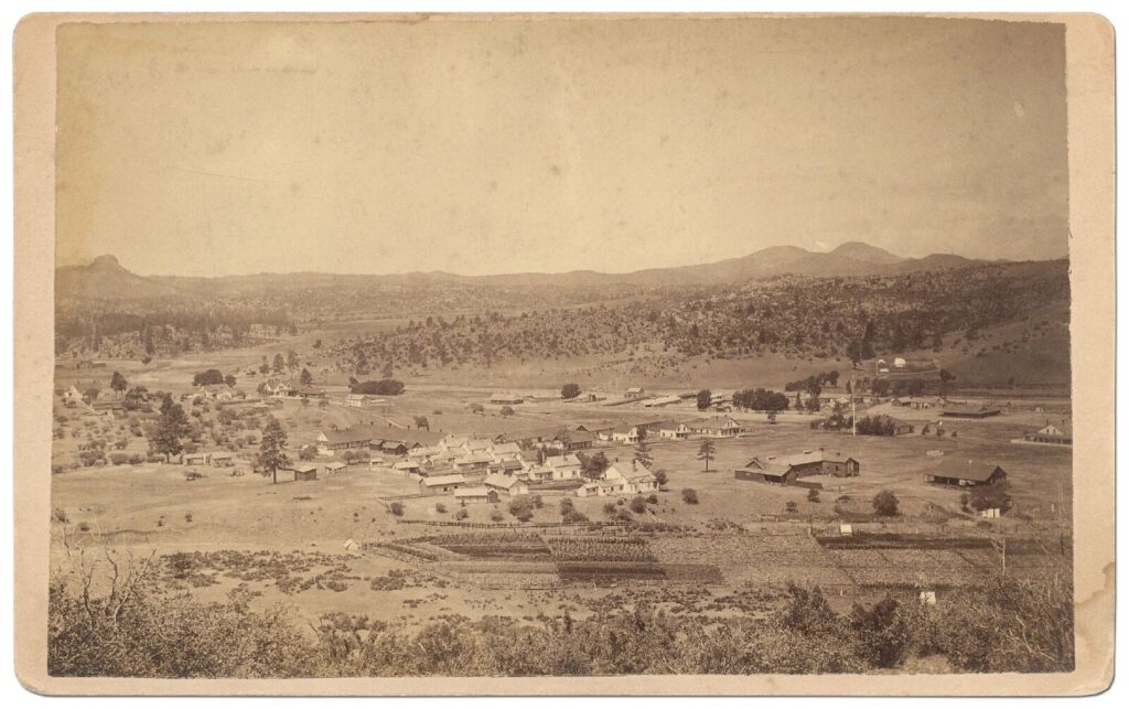
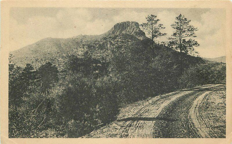
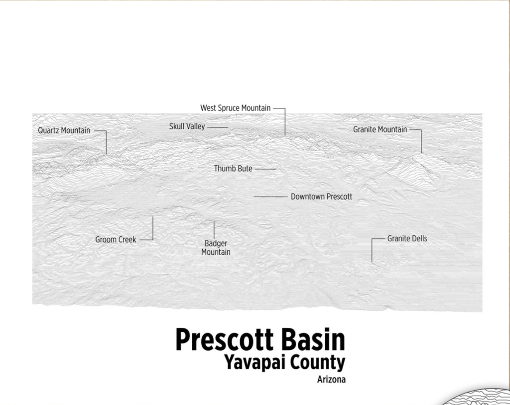
Highland Park, AZ Prescott Ariozna 1800’s Thumb Butte, Granite Mountain, ‘Aquarius Mountains’, Sierra Prietas, Fort Whipple Highland Pines Prescott, ArizonaMar 11, 2023Oct 4, 2023
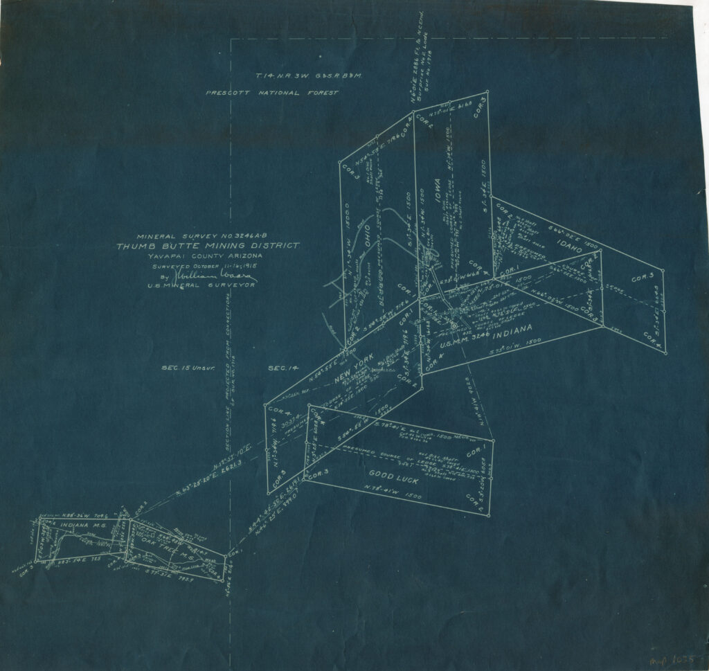
Highland Park, AZ MINERAL SURVEY MS3246, Yavapai County, Prescott Arizona T14N, R3W GSRBM Prescott National Forest, 1915 Mineral Survey 3246 A-B & Associated Millsites Present day Yavapai County Arizona GSRB&M Township 14 North, Range 3... Highland Pines Prescott, ArizonaMar 11, 2023Oct 4, 2023
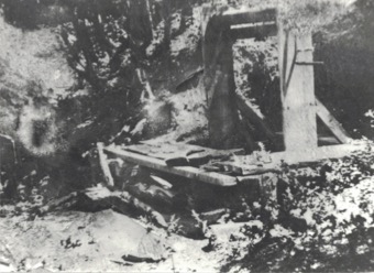
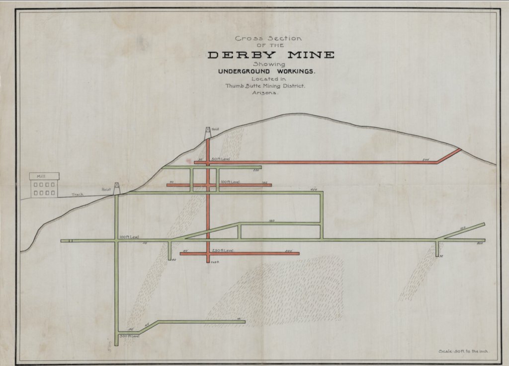
Highland Park, AZ Puritan Lode Claim, Derby Mine Underground Workings drawing: Puritan Mine or Derby Mine? Puritan Mining Claim Shaft at Derby Mine? Is this an illustration of the... Highland Pines Prescott, ArizonaMar 11, 2023Oct 4, 2023
Highland Park, AZ Theoretical Mines, Mining Claims Arizona, Thumb Butte Mining District ‘Derby Mine’ Mine Tales: The above illustration is simply that…an ‘illustration’. Conjectural depictions such as the various Derby Mine depictions... Highland Pines Prescott, ArizonaMar 11, 2023
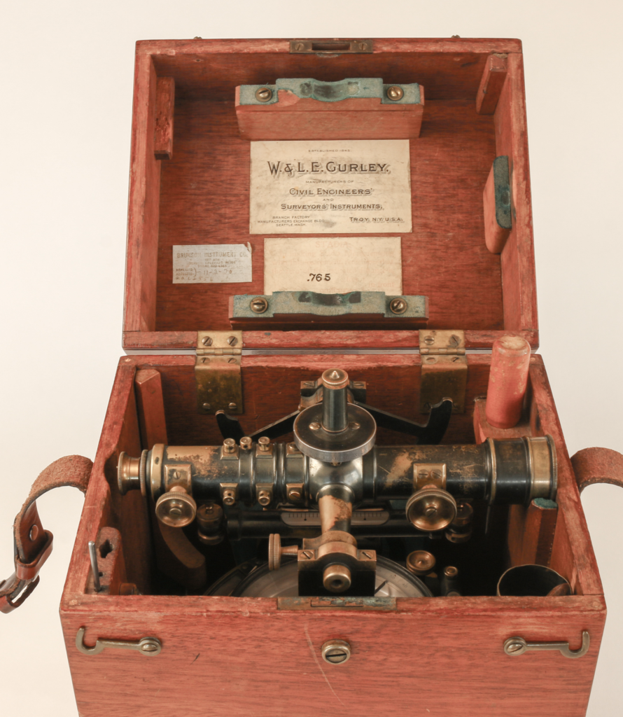
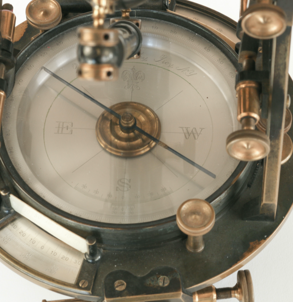
Highland Park, AZ ‘Gurley’ Light Mountain Solar Transit, 1907 A light mountain solar transit was the instrument purportedly used in 1907 for the United States mineral survey... Highland Pines Prescott, ArizonaMar 11, 2023Oct 4, 2023
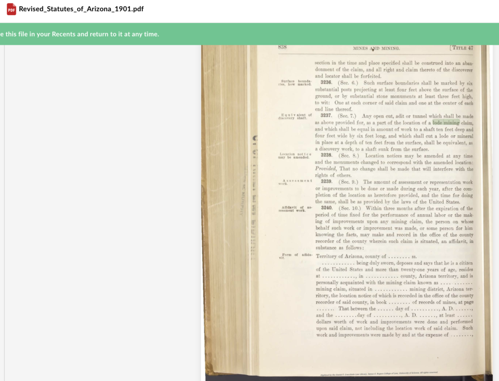
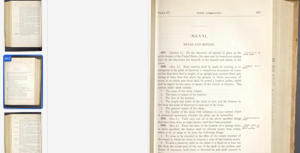
Highland Park, AZ Arizona Revised Statutes, Mines and Mining Title 47, 1901 Highland Pines Prescott, ArizonaMar 11, 2023
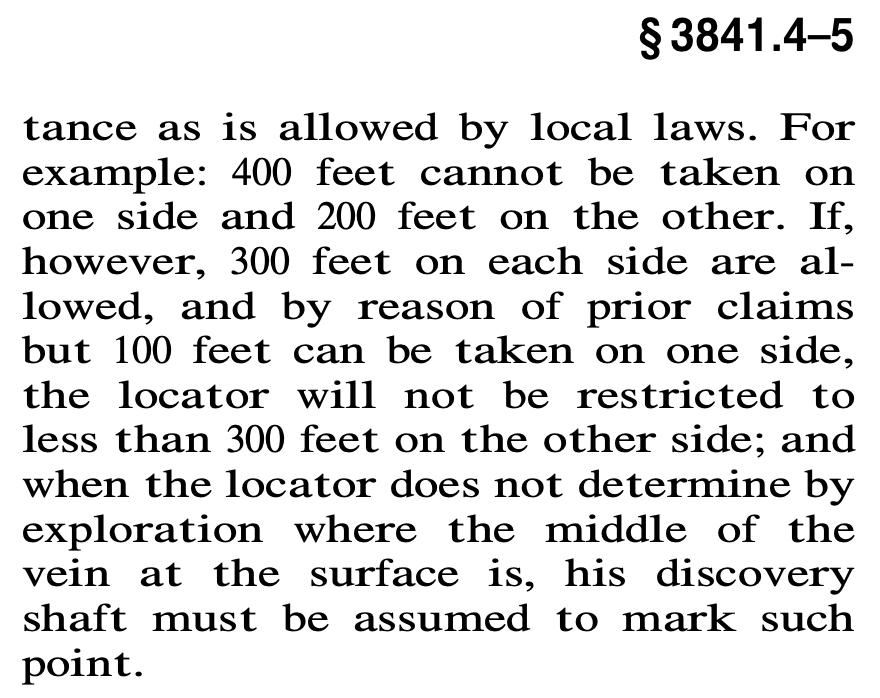
Highland Park, AZ 3841.5 Width of Lode Mining Claims, Notice of Mining Location Lode Claims, Mineral Patents Highland Pines Prescott, ArizonaMar 11, 2023Oct 4, 2023
Highland Park, AZ Lowry-Cross Lode Claim, James R. Lowry, ‘Lowry-Hill’ Highland Pines Arizona, Prescott Yavapai County Highland Pines Prescott, ArizonaMar 11, 2023
Highland Park, AZ Mining Reporter February 4, 1904 ‘What the Government is Actually doing to Mineral Patents’…’it is constructed on theoretical lines entirely’ Highland Pines Prescott, ArizonaMar 11, 2023Mar 24, 2023
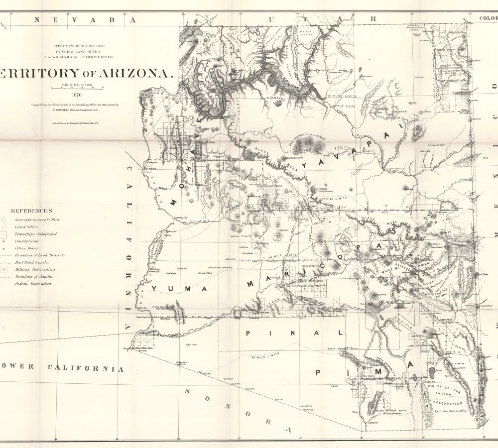
Highland Park, AZ Territory of Arizona Map, Department of the Interior, General Land Office 1876 Highland Pines Prescott, ArizonaMar 11, 2023Oct 4, 2023
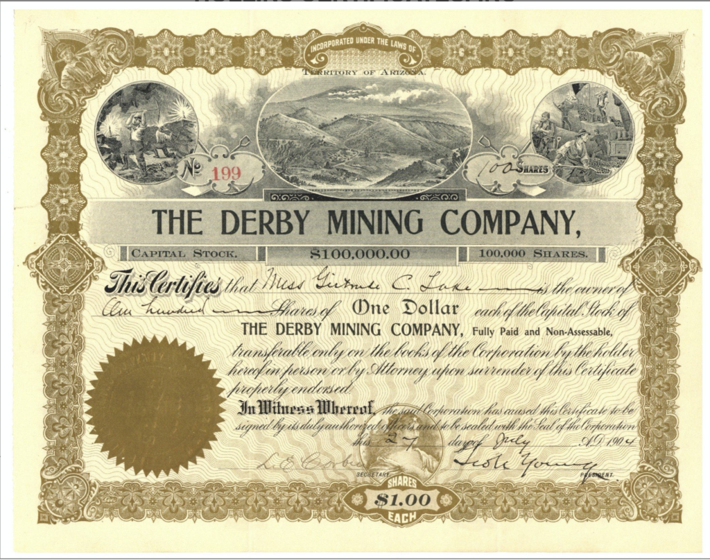
Highland Park, AZ The Derby Mining Company, ‘Derby Mine’ Stock Certificate, George U. Young 1904 Capital Stock $100,000! Highland Pines Prescott, ArizonaMar 11, 2023Oct 4, 2023
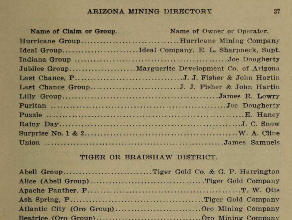
Highland Park, AZ Arizona Mining Directory 1899, Puritan Mine, Last Chance, Ideal Group, Lilly Group James R. Lowry Highland Pines Prescott, ArizonaMar 11, 2023Oct 4, 2023
Highland Park, AZ Arizona Revised Statutes 3238 A.R.S. , circa 1901 Mines and Mining Title 47, ” Amended Location Notices” Highland Pines Prescott, ArizonaMar 11, 2023Oct 4, 2023
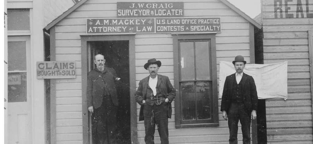
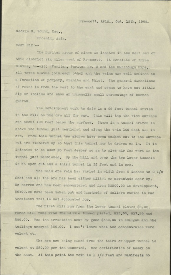
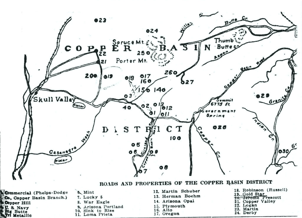
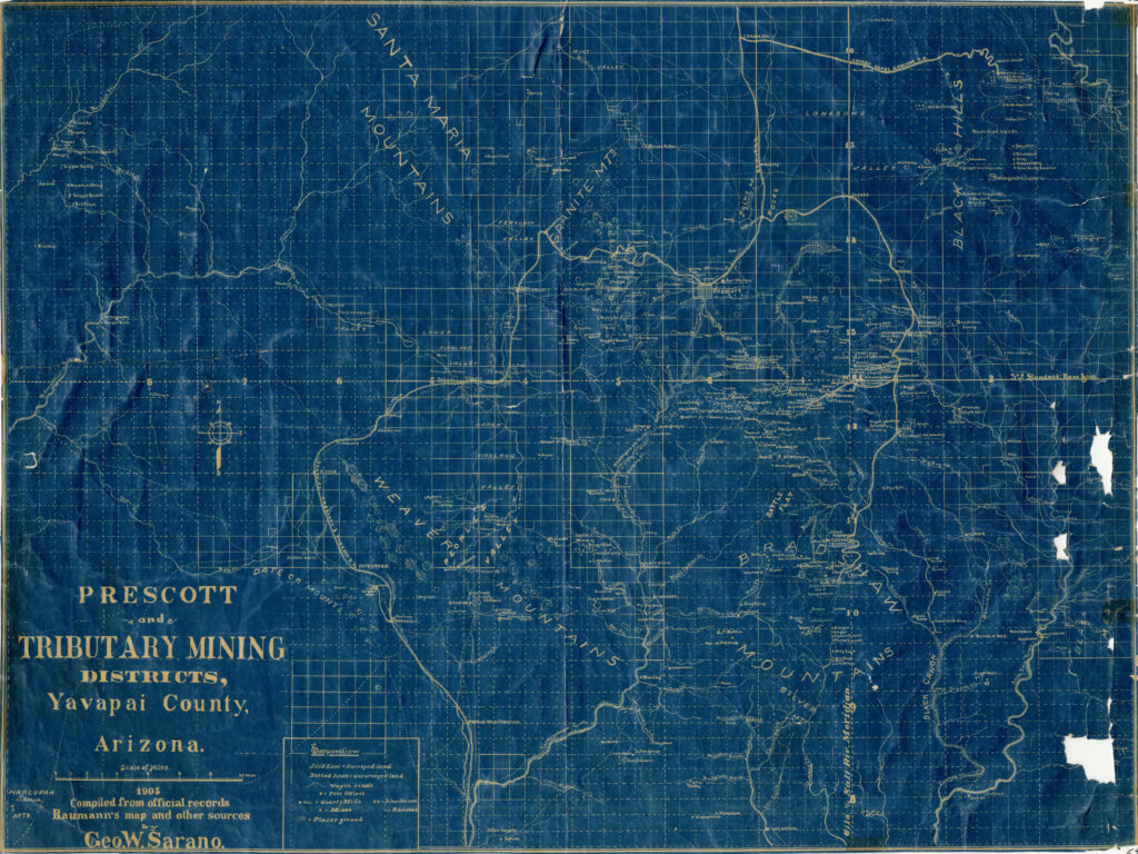
Highland Park, AZ George U. Young ‘Puritan Group of Mines’ letter October 12th, 1902 Puritan, Puritan No. 2, Surenough lode claims George W. Sarano was also the map maker of the 1903 Tributary Mining District of Prescott, and an... Highland Pines Prescott, ArizonaMar 6, 2023Oct 4, 2023
Highland Park, AZ Derby Mine location from Yavapai Magazine 1903, Copper Basin Mining District ‘Properties’ Highland Pines Prescott, ArizonaMar 6, 2023Oct 4, 2023
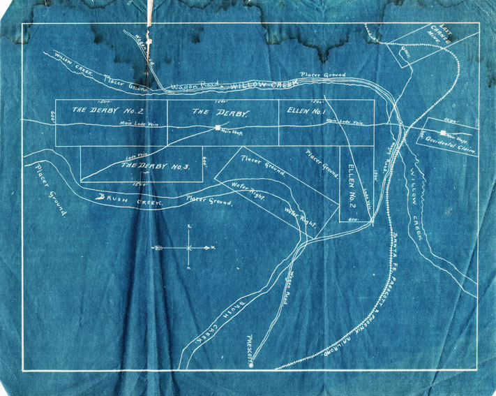
Highland Park, AZ Original Prospectus map ‘The Derby’ Derby lode claims, Prescott, Arizona Yavapai County, 1902 Map illustration includes lode claims of Derby Mine ‘The Derby’ and The Derby No. 2 and No. 3... Highland Pines Prescott, ArizonaMar 6, 2023Oct 4, 2023
Highland Park, AZ Prescott and Tributary Mining Districts, Yavapai County George W. Sarano Map, circa 1903 Highland Pines Prescott, ArizonaMar 3, 2023Oct 4, 2023